How Did WW2 Pilots Navigate Without GPS?
World War II was marked by intense, lengthy, bombing campaigns such as the Blitz, the German offensive against the city of London. Famously, one British response was the blackout, a defensive campaign to absolutely minimize lighting as much as possible. Considering the perspective of bomber pilots, who frequently conducted their attacks under the cover of darkness, it's difficult to fathom how pilots found their way without GPS.
Prior to the development of GPS systems, ship navigation centered around sailors' expertise using the positioning of the stars, specialized instruments such as sextants, and knowledge of landmarks along their route for orientation. For the pilots of the second World War, a lot of these same techniques were also key. Google Maps, digital devices in cockpits, and historic milestones for GPS navigation were still many decades away. Every sortie, then, was a tremendous risk in more ways than one.
Apart from facing opposing fighters and the arranged defensive measures at the mission destination, it was also a matter of finding your way there and back again. In order to do so, pilots used a combination of time-honored navigational tools, such as sextants and newer innovations like radio, which would revolutionize communication as surely as it helped aviators to determine their positions. The world of developing radar was an exciting and invaluable one for navigators, and the technology used during World War II would shape the future of navigation for pilots and aviators.
The importance of radio and radar
Radio access was limited by availability, and its systems were vulnerable to attack, making it unreliable. Nonetheless, the technology was invaluable. It wasn't simply a means of direct communication. Through a system of radio stations back down on terra firma, a pilot could follow frequencies using their aircraft's Radio Direction Finder to determine the position of its origin. Using other data points from additional stations, they could then gain an understanding of their own position relative to the stations. Some of the worst fighter planes of World War II were challenging enough to fly, so it was important that they at least knew where they were going.
Another piece of nascent technology of the time was radar. One application of this consisted of radio waves being used by operators who were seeking signals of reflected waves from approaching pilots. The British Dowding System, a network of radar stations and Observer Corps posts, was an enormous boon. According to the RAF Museum, MRAF Sir William Sholto Douglas believed the Battle of Britain couldn't have been won without the radar chain. Jamming radio signals cut off that vital source of knowledge, while inclement weather or cloud coverage made night flights an even more profound challenge.
Loran, or long-range navigation, was one of the Allies' huge innovations in this area. MIT developed this sophisticated system of stations. Positioned at strategic points on the ground, these stations emitted synchronized waves at timed intervals, making it possible to triangulate an aircraft's location based on the signals' rate.
Classic navigational techniques
Just as with aviation today, pilots and navigators don't rely solely on such technology. A U.S. aircraft flying to Europe from an American base has the ever-tricky task of finding its way over the ocean. What they fortunately had on their side was celestial navigation, a method that has been guiding travelers in the right direction for centuries. This is the science of using the stars to guide oneself, and it can be precise if the pilot is knowledgeable and skilled enough to wield a sextant accurately.
Some pilots were taught this highly advanced skill using the Celestial Navigation Trainer, which Popular Science described in April 1944 as "fuselage ... attached to the top of [a] column by a universal joint ... beneath the airplane was a screen, or terrain plate, which received the projected images representing any part of the earth's surface." Dead reckoning is another familiar method of navigating in an aircraft, a way of using a landmark already set and known to determine movement relative to that position.
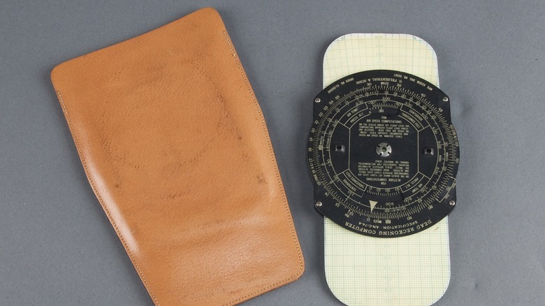
In order to help with this, the E6-B, a variant of the Dalton dead reckoning computer was used during the conflict. A complex-looking device, it simplifies the process of making navigational calculations by providing the answers to formulas via dials and systems that are turned. Alongside other tools like compasses and protractors for making accurate measurements on maps and charts, World War II navigators had access to a mixture of cutting-edge technology and time-honored methods for finding their way.


