Road Trip Bucket List: 10 Essential Grand Touring Routes Worth The Journey
Chances are that no matter where you live, there are some nearby drives known for their scenic beauty, whether it is through rolling hills, mountainous peaks, or flatland desert. Furthermore, what constitutes a scenic drive varies from one individual to the next. However, those who truly enjoy being behind the wheel can almost universally agree that finding a route to leisurely take in scenery, whether natural or manmade, is an enjoyable pastime.
The idea of a Grand Tour, which is probably what inspired the sports car designation GT, actually precedes even the automobile itself. It dates back to the 17th century as the expression is credited to a travel writer and Catholic priest, Richard Lassels, who first used the term in his 1670 guidebook "The Voyage of Italy." For the English, embarking upon a Grand Tour typically began by sailing to France and continuing south until reaching the great cities of the Italian peninsula such as Venice, Florence, and Rome.
The Grand Tour as a singular institution went away around the time of the French Revolution but has continued in spirit, kept up by intrepid drivers intent on seeing the sights of the world through the eyes of a traveler. In the modern day, this has evolved into one of many highway routes through which travelers may take in the splendor of the world, often on roads dedicated to leisure driving. Here are ten excellent examples to include on your bucket list.
Stelvio Pass
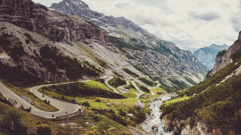
The northern region of Italy at the foothills of the Alps is called Lombardy, of which Milan is the largest metropolitan area. Just a bit further north are dozens of alpine villages dotting the mountainous landscape with a road originally built by the Austrian Empire to connect its province of Lombardia to greater Austria. However, in creating roads for transportation, the Austrians also inadvertently created a challenging road course through breathtaking scenery that has become a destination unto itself — Stelvio Pass.
Traveling from the south, the pass begins, depending on who you ask, in Bagni di Bormio and heads in a roughly northeastern direction for about 30 miles, ending in the German-speaking Italian village of Prad am Stilfser Joch. The path taken runs between some of the highest peaks of the Alps that feature ski resorts among amazingly placid and clear alpine lakes. Elevation by the time you get there reaches above 9,000 feet, and the Stelvio Pass is the highest paved road in the eastern Alps.
Be forewarned with the beauty comes a challenging drive. In those 46 miles over the Alpen summits, you will experience dozens of switchbacks and hairpin bends, often with little to no warning. It is among the most challenging roads in the world, but driving it successfully will be equally rewarding. To achieve these great rises in elevation, roads must wind back and forth up and down the peaks to prevent having a grade too steep for driving, but it can still be a bit alarming. The rewards of the drive and the majestic view shall make this a journey you'll never forget.
Tail of the Dragon
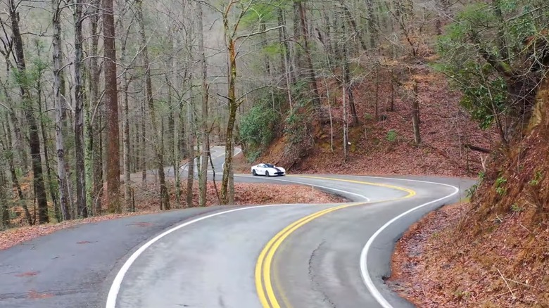
Lying along a stretch of the border between Tennessee and North Carolina are the Great Smoky Mountains, part of the greater Appalachian range. Woven between the peaks in an area known as Deals Gap is highway US 129, of which there are 14 miles of particularly curvy road known as the Tail of the Dragon. While the route is short, it is not without excitement as it features 318 curves in just 11 miles of asphalt ranging from 1,000 to 1,800 feet in elevation. This has made it a popular destination for drivers for decades and has even been featured in several movies such as "Two Lane Blacktop" and "The Fugitive."
The Dragon is especially popular in the fall when the colors of the thickly forested hills come alive with the colors of fall, although it is a delightful cruise at any time. Although this course is attractive to adrenaline junkies, the drive is a modest course in reality, and the speed limit is set at 30 mph. Unlike a treacherous mountain road in the Rockies, full of switchbacks and hairpins, the Dragon features abundant winding curves with mild banking that make for a leisurely drive through a picturesque area rich in nature and American history with plenty of opportunities for scenic stops.
No other roads intersect the course and it is generally open year-round, barring accidents or weather-related closures. Sections are occasionally closed for filming of ads or movies, but racing is never allowed. Rallies are regularly scheduled by enthusiasts of sports cars and motorcycles. Aggressive driving is frowned upon, and citations are issued to anyone doing something stupid or dangerous.
Talimena Scenic Byway
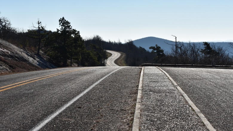
Most people not from the area likely think of Oklahoma as nothing but flat prairie and farmland. However, tucked away in the southeastern portion of the state are the Ouachita Mountains, a range of gently rolling hills full of beauty. The Ouachita range covers some 2,800 square miles of this region with peaks rising to just under 3,000 feet. Their natural beauty is within the Choctaw Nation and lies hours from any population center. Right in the middle of all of this is a dedicated scenic drive called the Talimena Scenic Byway.
Built in the 1960s, Talimena Drive runs from Talihina, Oklahoma for 54 miles to Mena, Arkansas. This route runs along the tops of the Winding Stair Mountains, providing overlook stops along the way with views of the valleys and peaks in the distance. With lush vegetation surrounding it, fall is the preferred time to visit but it is full of natural beauty year-round. Ample places to stop are provided throughout the route, providing opportunities for hiking and exploring nature, with the Robert S. Kerr Arboretum and Nature Center situated about halfway through for additional nature exploring.
Once crossing into Arkansas, you will find the Rich Mountain Lookout Tower, with an observation deck that stands at 2,682 feet, the highest point on the route. At the terminus near Mena, Arkansas is the Queen Wilhelmina Lodge, where you can stop for a meal while stretching your legs. While this is a remote part of the country and very distant for most city dwellers, it is a worthwhile escape into nature into a part of the country that is often overlooked.
State Route 1
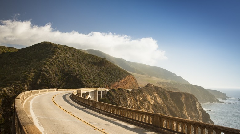
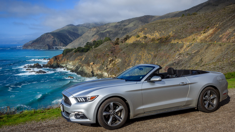
Many taking a trip from San Diego to San Francisco will either fly direct, drive up Interstate 5, or opt for one of the daily Amtrak routes. However, those with a little extra time to spare who want to throw some sightseeing into their itinerary choose California State Route 1 or the Pacific Coast Highway (PCH). The complete PCH runs from San Diego all the way to Olympia, Washington, switching from State Route 1 to US 101 in Oregon — a 1,675-mile journey. A much more manageable drive begins and ends in California while keeping the entire drive scenic.
It is recommended to travel south for unimpeded views of the ocean along the way, which also lets you start in historic San Francisco. The route to the border is roughly 500 miles, so this one is also good for a few days with plenty of stops and relaxation in mind. Along the way, you will be treated to some of the most stunning ocean-side scenery on the planet, with multiple bluffs, beaches, and estuary coves with wildlife preserves to see. You'll pass through several small towns with unique shops and restaurants ready to cater to travelers with exotic specialties.
This is perhaps one of the best ways to experience California. It keeps you wrapped up in the Earth's natural beauty while offering brief excursions into the hustle and bustle of the city, keeping you away from the worst of California's infamous traffic snarls.
Skyline Drive
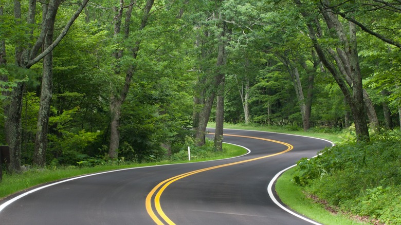
About an hour's drive from Washington D.C. is the Shenandoah National Park, which runs across the state of Virginia and was one of the first national parks in the eastern United States. Within the park is Skyline Drive, a scenic highway across the Appalachian peaks that make up the national park. Built in the 1930s, Skyline became part of an experiment of the federal government to take land once inhabited by humans and return it to its natural state. The road opened in 1939 and has been one of the most popular scenic roads in America ever since, for good reason.
Coming from D.C., Skyline Drive begins at the park entrance at Front Royal, Virginia, and continues for 105 miles over the tops of the Blue Ridge Mountains across northern Virginia. As the main road of the park itself, the drive is free with park admission. The road is gentle and winding, with overlooks placed throughout the route, offering expansive views of the valleys on both sides of the ridge.
Vegetation is thick and lush, with wildlife aplenty, offering opportunities for activities such as birdwatching around every bend. The mountain vistas at around 4,000 feet provide views for miles around at any stop. Skyland can be found at the highest point in the park, offering mountain-top dining and lodging in rustic cabins in an area that originated as the Black Rock Spring Hotel in the 1830s. The views are worth the drive.
Trail Ridge Road
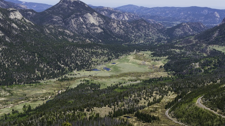
Driving out of Estes Park, Colorado toward the Continental Divide, you will find yourself on the Trail Ridge Road heading into the Rocky Mountain National Park. Before the 1930s, the Fall River Road was the primary road to the western slope but had become overburdened by the traffic as it was too narrow and mostly unpaved. The new road was completed in two parts and finished in 1938, taking great care during construction to conserve the landscape and maintain its natural beauty.
For those who have not been to the area, it is hard to describe the stunning beauty and breathtaking awe of the landscape. The Rockies are such a majestic sight that you can just stand and stare into the distance, feeling perfectly content to take in the sights, sounds, and smells of nature. However, the air is thin at this altitude, which takes getting used to and can make physical activity difficult. In fact, 11 miles of this 48-mile route sit above 11,000 feet and it starts from Estes Park, which is already at 7,522 feet. It is best enjoyed outside of winter months.
Once there, you will see amazingly huge snow-capped peaks to the west while surrounded by forests of lush pines and alpine grasses. Lookouts and rest areas can be found throughout, including some at which you can park and stroll around crystal clear mountain lakes fed by snowmelt just above you. Ice-cold streams crisscross the terrain full of wildlife such as chipmunks, bald eagles, and bighorn sheep.
Romantic Road
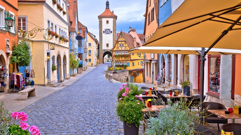
This scenic route through the middle of Germany is not so much a single scenic road but a planned journey through the heartland of the country which will expose travelers to the most quintessentially German villages in the country. This trail rests primarily in the states of Bavaria and Baden-Württemberg, roughly following the routes of long-disappeared Roman roads through the region. There was no authentic historical tradition associated with the route -– it was developed to promote tourism in the war-ravaged country of 1950. Regardless, the idea took off.
Traveling from the north, the Romantic Road takes you from Würzburg south to Füssen at the Austrian border. Using only regular roads and avoiding the Autobahn, you will find yourself going through up to 28 towns, making it necessary to do some research to decide which ones deserve a stop. The villages along this route have been inhabited for centuries and contain beautiful examples of medieval and Gothic architecture. Highlights include Rothenburg, known for its historic walled town with fairy-tale charm, the 11th-century Harburg Castle, and the incredible Neuschwanstein castle on a hill that inspired the castle at Disney's Magic Kingdom.
While there are tours available for this trip, it is best enjoyed in your own car. That allows complete freedom to visit only the sites you want and at your own pace. This is a beautiful part of the Old World with many individual towns and villages that are well worth a visit.
Route 66
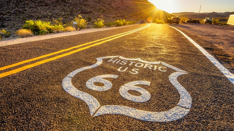
For a long American road trip, there can be no better choice than Route 66. This is a national highway stretching from Chicago to Los Angeles that cobbled together existing state highways in an effort that began with the Federal Aid Highway Act of 1921. It grew into the primary link of people and goods from the east to the west of the United States. It facilitated Western migration during the Depression and military logistics during WWII.
While the Interstate Highway System replaced much of Route 66, you can still see the country on the existing portions for an exciting sightseeing tour of the country. However, it should be noted that traveling the entire run of the original Route 66 will be a journey of 2,400 miles and will take a bit of time. That said, an ideal trip will start in Chicago and end on the beach looking at the Pacific Ocean off the end of the Santa Monica Pier, the (unofficial) terminus of Route 66.
There is a lot to see through the seven states through which the route passes mixed with long stretches of nothing. Along the way, you can visit the Gateway Arch in St. Louis, press your luck at the Hard Rock Hotel & Casino in Tulsa, find an old-time diner or three, stay at the Wigwam Motel in Holbrook, Arizona, and eventually find your way to Santa Monica. While these experiences are iconic, they are just a few of the dozens of things you can see and experience and the amazing diversity of American people and places you will encounter along the way.
The Alaska Highway
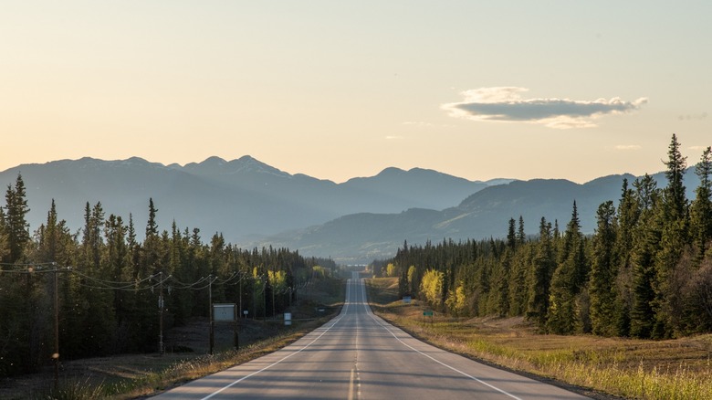
You might think something called the Alaska Highway would take you through America's largest state, but you would be wrong. It does end in Delta Junction, Alaska, but it begins in Dawson Creek, British Columbia, and two-thirds of it lies in Canada. Nevertheless, those who are not afraid of a challenge and love traveling through landscapes of majestic conifers should consider taking this route up north.
The Alaska Highway is a 1,523-mile road connecting Alaska with the rest of the North American continent. Completed in 1942, it served as a vital route to American military forces stationed in Alaska. While it is located in cold and remote territory, it serves a surprising amount of traffic with food, fuel, and lodging found throughout the route, although they can be spaced far apart. While you will not find cell phone service along the way you will find breathtaking views throughout. This runs through the mighty Northern Rockies, which boasts of miles and miles of untamed wilderness and jagged peaks in excess of 10,000 feet featuring grand glaciers in between.
Dawson Creek is already a long way from nowhere, so this journey is only for strong-willed and adventure-prone individuals, as danger lurks everywhere. Bears are common but moose are probably a bigger danger to drivers. Solid preparation is essential, but the reward of this accomplishment is well worth it.
Route 100
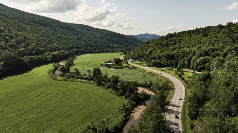
For a trip that blends natural beauty with history and Americana, you can do no better than Vermont's Route 100 scenic byway. Running from north to south from Massachusetts to Canada, Route 100 is a delightful and stunningly beautiful journey to take at any time, though the foliage in October is when Vermont is at its best. However, skiers might want to visit more in the winter months as the slopes found in the Green Mountains are world-class.
This 216-mile journey takes travelers through the heart of Vermont along the eastern side of the Green Mountain range. It follows the rivers and contours of Vermont on a route dating back to the 1700s. Travelers will be able to experience 33 of Vermont's charming and historic towns and villages along the way, with ample opportunity to sample local fare and pick up some handiwork from the many artisans and craftsmen who call Vermont home. These include the village of Weston, which is on the National Register of Historic Places for its overwhelming percentage of historic buildings and the birthplace of Ben and Jerry's ice cream in Waterbury.
No matter where you go in Vermont, there is something for everyone. Despite being such a small state, there are still plenty of open spaces to explore, and the historic architecture and covered bridges add to the charm and natural beauty to be enjoyed along this route.