What Is LiDAR And How Does It Work?
LiDAR, short for light detection and ranging, sounds like the sort of made-up term you might find coming out of the mouth of an engineering officer on a fictional starship. It rolls off the tongue in the same fashion as phaser or unobtainium. Despite its fake sounding name, it is a very real technology which uses laser light to measure to distance between an object and an observer.
That light, when coupled with modern sensors and GPS technologies, is capable of tracking distant objects as they move and crafting high resolution 3D maps of objects and environments. LiDAR uses a similar philosophy as RADAR to function, but because the wavelengths are smaller, the resolution is much higher. By way of analogy, if LiDAR is a high-resolution photograph, RADAR is shadow puppets on a cave wall.
The technology, while relatively new, has infiltrated various facets of scientific research and everyday life. It's found its way onto aircrafts, spaceships, and might even be in your pocket right now. So, what is LiDAR, how does it work, and what new knowledge and capabilities has it given us?
What is LiDAR
LiDAR is considered an active remote sensing system, which means it generates energy in order to measure something, instead of simply taking in energy already apparent in the environment. It works under a similar philosophy as radar, hence the common associations in the popular imagination, but instead of bouncing radio waves, these systems use laser light.
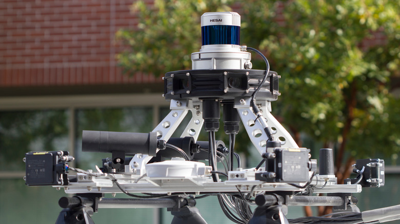
Recognizing LiDAR on sight might prove difficult owing to the drastic differences among varying systems. Depending on its intended function, LiDAR systems can range from large devices mounted on aircraft to small handheld devices for personal use.
Regardless of the specifics, all LiDAR systems are comprised of two major components — an emitter for sending light out into the environment and a sensor for gathering light on its way back to the device.
As LiDAR technology has improved, the costs have come down significantly. Relatively recently, LiDAR regularly cost tens of thousands of dollars for a single system. Now, the tech is affordable enough to be included in common smartphones. You might actually own one now without even knowing it.
How does LiDAR work?
Light is emitted from the LiDAR system out into the environment, typically in pulses. That light then travels into the environment where it encounters an object. The objects LiDAR is capable of measuring are various and include natural and artificial constructs like plants and animals, buildings, or whole planets.
Once the light encounters an object, it bounces back, where it strikes a sensor. Because the speed of light is constant, the time between emission and reflection back into the sensor provides useful data regarding distance. The system measures the time it took for the light to travel round trip and uses that to calculate a distance.
Because the wavelength of laser light is comparatively short, it is capable of measuring distances in high definition, when compared with previous technologies like radar. Instead of getting nondescript blobs indicating large objects, LiDAR can provide high-detail models of objects.
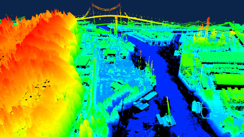
In this way, LiDAR systems are capable of building detailed 3D maps of objects or environments, something which has been accomplished in a variety of fashions since its invention. We'll talk more about how LiDAR has been used in every imaginable kind of environment later on.
How you can use LiDAR right now

You might be able to get in on the LiDAR action. Why should scientists have all the fun? Certain models of iPhones and iPads have LiDAR built right into the camera array, pre-installed and ready for you to toy around with.
It's the little black circle nestled next to the cameras and light. If you have an iPhone Pro, twelfth generation or later, or an iPad Pro, second generation or later, then you have your very own LiDAR in your pocket or bedside table.
Apple's LiDAR system enhances many of the already existing applications on your phone, particularly the Measure function and your camera's ability to focus, by more accurately determining the distance to and between objects (via Apple). This is also handy for AR games and apps by allowing virtual objects to more realistically interact with the real world. The LiDAR function also allows you to capture 3D images of objects and places in the real world, letting you do some of the cool stuff listed above, albeit to a lesser degree.
If you're an Android user, you're out of luck — at least for the time being. Android previously had Project Tango which aimed to achieve many of the same functions, but as of December 2017, support for Tango was shuttered.
That means that for now, Android users have been left in the dark when it comes to contemporary 3D scanning abilities. Here's hoping that changes soon.
How LiDAR benefits modern archaeology
Because the Earth is geologically active, awash in tectonic and weather activity which builds things up and erodes them away, finding objects from the past can be quite difficult. Despite having mapped the total surface of other planets, there is still much about our own world yet to be discovered, shrouded in hard-to-reach places.
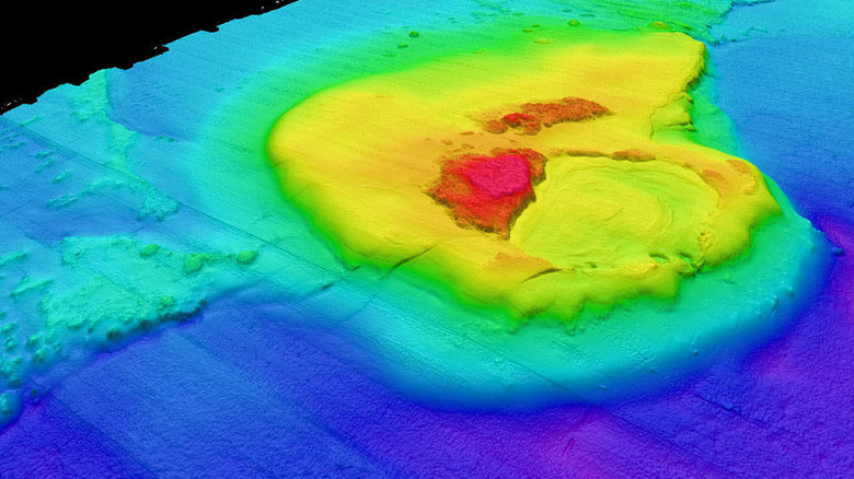
Archaeologists use LiDAR systems deployed from planes flying overhead to gain robust maps of potential dig sights. Because LiDAR can deliver maps with astonishing detail and grant a larger bird's eye view of an area, scientists are able to find sites of interest they might otherwise have missed.
Recently, an aerial survey using LiDAR uncovered the oldest and largest Mayan structure discovered to date. Even looking at photos of the area from above won't reveal the site, but remote sensing did. Since its introduction to the field of archaeology, LiDAR has revealed countless ruins and potential new dig sites which might have been lost to us forever if not for this incredible technology.
The benefits of LiDAR aren't limited only to uncovering the past. The technology has made an impact from the oceans all the way to outer space.
Mapping shorelines and the ocean floor
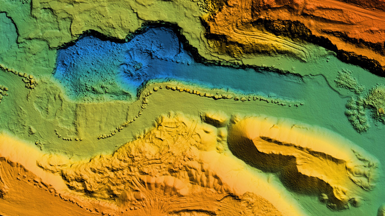
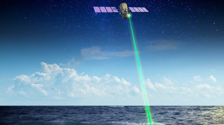
LiDAR isn't only useful for mapping the ground or objects in outer space, it's also useful for gaining a clearer picture of the oceans. While topographical mapping often uses a near-infrared laser, bathymetry — the practice of mapping the ocean floor — takes a little ingenuity.
Because of the way water scatters light of different wavelengths, some types of laser light penetrate better than others. In order to move more readily through the water column, scientists use green laser light to map the ocean floor (via NOAA).
There is, however, a limit to how far LiDAR can penetrate into the water column. The deepest parts of the ocean are devoid of light precisely because it eventually gets scattered too much and can't penetrate further. At great enough depths, even laser light gets lost.
Luckily, that isn't a problem for shoreline mapping. Shorelines naturally change all the time, as a consequence of wind, water, and tectonic forces. Using LiDAR can allow us to capture near-real-time maps of these shifting boundaries.
Shining a light on agriculture

LiDAR isn't only useful for crafting maps of Earth and other planets; it can also provide helpful information to farmers about the state of their crops and which interventions are working better than others (via Fly Guys). A LiDAR system pointed at a field of crops can return data about the height and density of a single plant or an entire field. If we know the average weight of a plant, that information can be used to estimate biomass and crop yields. That's something that's useful to know if you're depending on a crop to feed your family, either directly or economically.
By scanning different plots of land undergoing diverse crop treatments or in varying soil conditions, farmers can get ready insight into what's working and what isn't, allowing them to make adjustments before the season is out. Moreover, with the advent of drones, farmers need not even employ the use of LiDAR equipped airplanes. Instead, flying an appropriately outfitted quadcopter over a field is enough to gain useful data about crop yields.
Farmers can, of course, use LiDAR in advance of planting to develop the maps for which the technology has become so well known. Doing so can reveal changes in water flow and access to natural resources which might inform decisions when it's time to lay seed.
Tracing pollution to its source

Air pollution has become an increasing problem since the industrial revolution (via EPA). It is especially a problem in cities where a higher concentration of pollution sources is present. Unfortunately, air pollution is often invisible to us and easily forgotten, despite having a huge impact on public health. Traditionally, levels of air pollution have been studied from ground-based monitoring stations. These stations are limited to measuring particulates within a local area, and gaining a picture of a larger region requires multiple stations situated at intervals.
Conversely, LiDAR can be made mobile, allowing it to gather data across a wider area in real-time. With that in mind, scientists have crafted a system that uses laser light to measure how strongly the air absorbs light — a measurement known as the "extinction coefficient" — in a given place. A higher extinction coefficient is indicative of higher levels of particulate pollution in the air.
This data allows us to identify regions of high pollution and trace the pollution to its source, Science Direct notes. It also provides crucial information about levels of exposure to a population faster and in more detail than was previously possible. While this is a relatively new technique, it hails back to the early days of light detection when LiDARs predecessors were measuring atmospheric conditions with light.
Self-driving cars
Modern cars have all sorts of sensors that assist drivers in maneuvering. If you've bought a new car in the last several years, it has a reverse camera and sensors for when you're too close to something.
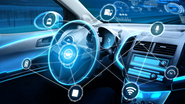
Self-driving cars take these tools to an extreme by utilizing them to drive on behalf of a human operator. Tesla, perhaps the most well-known self-driving car manufacturer, has put their nickel down on computer vision. They utilize cameras that feed information to a neural network in order to make decisions. While the debate over optical cameras versus LiDAR rages on, the majority of other manufacturers use the latter.
You might have seen LiDAR at work if you've ever encountered one of Google's autonomous vehicles on the road. The roof-mounted system sends out light and uses it to build a map of its surroundings (via IEEE Spectrum). However, doing that in a moving vehicle on uneven terrain can be complex. To make it all work, LiDAR-equipped cars also have an Inertial Measurement Unit which tracks real-time changes in angle to ensure the LiDAR creates an accurate map for safely maneuvering the roadway.
Mapping the moon and Mars
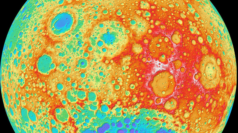
By 1971, LiDAR hit the big time, having been included in Apollo missions (via NASA). Instead of pointing itself toward space from Earth in search of satellites, now it was being sent to space itself in hopes of mapping other worlds.
Its first use in a spacecraft occurred during Apollo 15, NASA noted, and later during Apollo 16 and 17. It was aimed from lunar orbit to build detailed maps of the Moon's surface. Moreover, Apollo missions left large mirrors behind on the surface of the Moon which are still used today to measure the distance to the moon from Earth, down to centimeter-level accuracy.
Later, NASA sent improved LiDAR systems to Mars to map its surface. More than 600 million measurements have been made. Because LiDAR is capable of delivering measurements with incredible accuracy, we've been able to gain topographical maps of the geography of other worlds without ever having to set actual eyes on them.
LiDAR's limitations and downsides
We should be clear that LiDAR is not a perfect technology, the answer to all of our mapping and data gathering needs. Some of the characteristics that make LiDAR so useful for gathering information under specific circumstances, can prove to be limitations in other settings.
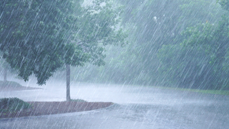
Because the light bounces or scatters off of any number of objects, including particulates in the air, that can limit its utility. For instance, when weather conditions are poor, precipitation in the air can prevent the system from clearly painting a picture of its surroundings. This might be especially relevant for LiDAR based automated driving technologies, which might often be called upon to operate in poor weather conditions.
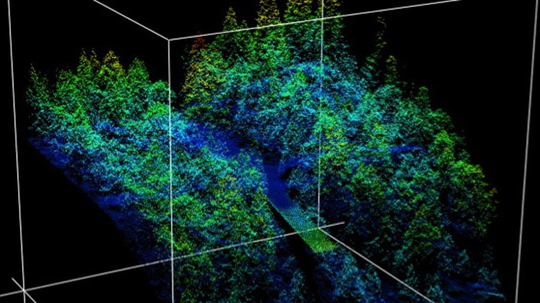
Likewise, when mapping vegetation like farmlands or forests, dense growth can prevent LiDAR from penetrating to the depths needed to be truly useful. Thick forest canopies can prevent the light from getting through the forest floor. Additionally, as mentioned above, there is a hard stop when attempting to map through the water column.
In these instances, other technologies including RADAR or manual data collection might be more suitable solutions.
LiDAR's predecessors
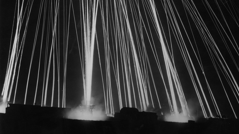
Since the 1930s, light has been used as a way of sensing distant objects, including the upper atmosphere (via Brittanica). Scientists wanted a method of measuring the distribution of particles in the atmosphere at high altitudes, and they settled on powerful searchlights as a possible solution, according to a study published by OSA Publishing Group. By setting up a searchlight near an observation station and directing the beam of light up through the atmosphere at an angle, researchers could photograph the beam and measure its properties. The beam of light was visible to between 20 and 28 kilometers in height, depending on the clarity of the sky on a given day.
Measuring the intensity of the light at different altitudes provided insight into the number of particles present in the atmosphere at different altitudes, the study found. This method of observation was challenging, owing to the background light of the moon and stars in the night sky. Scientists solved this problem first by using a collection of searchlights collected into a single beam with a mirror, and later by using a modulated searchlight such that its signature could be tagged and isolated from the background.
These methods allowed for some of the earliest attempts at observing the high atmosphere.
Invention of the laser
The idea for lasers or similar devices had been floating around the scientific community since Einstein first suggested the concept in the early twentieth century. Progress was made over the next few decades, primarily in generating microwave radiation through stimulated emission, but the applications were sparse (via Physics Today).
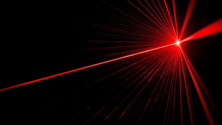
The trick, it turned out, was in creating light emissions at shorter wavelengths. This idea took hold in the mid to late '50s but wasn't successfully achieved until 1960. That year Theodore Maiman, then working at Hughes Research Laboratory, shined a photographer's flashlamp on a piece of modified ruby and observed that it produced red pulses of visible light. The resulting research was published in the journal Nature.
At first, scientists weren't quite sure what to do with this new technology. But that soon changed. Lasers quickly found their way into nearly every field of scientific inquiry and are a common part of everyday life today, as noted by American Scientist.
First use of LiDAR
While Maiman is credited as inventing the first functional laser, he was working for Hughes Aircraft Company at the time, and they became the first beneficiary of the technology. Only a year later, in 1961, the company developed the first working LiDAR system.
At the time, however, it wasn't called LiDAR. That term wouldn't enter into scientific parlance for another couple of years. It built on the previous work in making measurements using light, only this time with a more efficient and powerful source than spotlights.
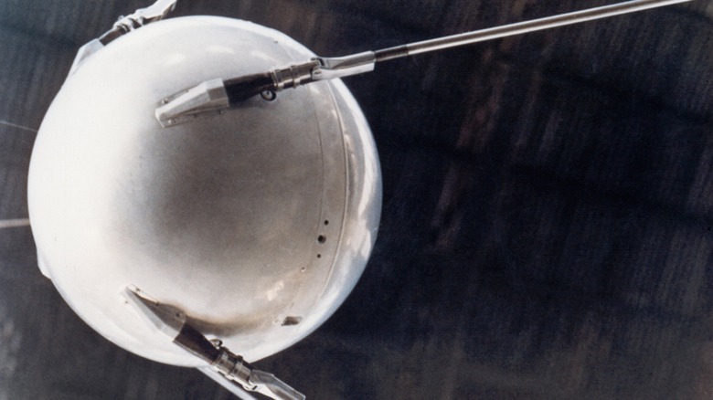
Like many new technologies, the first LiDAR system quickly became of interest to the military (via IOP Science). A few years earlier, in 1957, the Soviet Union launched Sputnik, the world's first satellite, kicking off the space race. Knowing where satellites were and what they were up to was a priority in the wake of the public fear generated by the existence of Soviet satellites. With that in mind, the military partnered with Hughes to put a LiDAR system into operation for the purpose of tracking satellites.
From concept to world domination and beyond
We might have been happy with the advent of lasers even if they were only useful for driving your cat — literally — up a wall. Instead, lasers found a home in countless devices we use every single day.
Without them, and their use inside detection and ranging tools, we'd have missed out on knowledge from just about every scientific discipline. LiDAR has helped to illuminate civilizations from our distant past and build roadmaps to our future on the moon and other planets.
As we've seen in this article, this technology is helping to reduce food scarcity and the prevalence of pollution in our cities and neighborhoods. It's making your commute safer and providing new avenues for building games and documenting the fun you have with family and friends.
Whether you know it or not, LiDAR has likely touched your life in one way or another. Simply by measuring the distance between things, we've been able to draw a better future a little bit closer.