This Google Earth Feature Lets You Digitally 'Time Travel' - Here's How It Works

Who among us hasn't wished for the ability to time travel. Unfortunately, you can't hop in a DeLorean, gun it to 88 miles per hour, and visit the past. However, Google Earth has the next best thing for thehistory nerds: a feature called Historical Imagery that allows you to view satellite photos from any time since satellite imagery was taken in a particular location. It can reveal the way areas have changed over time, providing context that isn't available from the latest satellite updates on Google Maps.
This feature has applications both personal and professional. That neighborhood that used to have vibrant, local charm before getting gentrified? You can relive it — albeit with grainy satellite footage — to take a trip down memory lane, while a real estate developer might look at those same changes to help determine the future value of a property. Urban planners can examine the way a city has changed over time to understand where critical infrastructure is needed. Environmental scientists might use it to view deforestation, retreating ice caps, or eroding coastlines. Whether you're after nostalgia or hard data, it works just the same.
In fact, Google has recently extended this feature to Street View, making it easy to see on-the-ground footage of changes to an area over time. However, accessing Google Earth's Historical Imagery features can be a little bit tricky, especially if you're using the mobile app. Read on to learn how to manipulate time via satellite imagery, as well as how to view a timelapse of a given area and the feature's limitations.
How to time travel with Google Earth's Historical Imagery feature
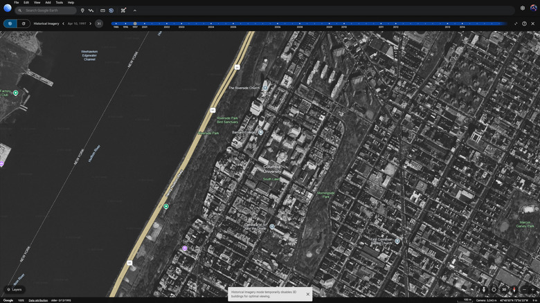
On the browser version of Google Earth supported on desktops, you can access Historical Imagery by clicking the Historical Imagery button, which is represented by an icon that looks like planet Earth with a reverse arrow wrapped around it. Alternatively, you can click the Layers button in the bottom left corner of the window and then switch on the Historical Imagery toggle.
If you're using the mobile app on Android or iOS, you'll need to enable Historical Imagery by clicking the layers button in the top right corner. It looks like one square stacked atop another. Scroll down and toggle on the Historical Imagery option to enter the time travel mode. You will need to do this each time you want to use Historical Imagery.Once in Historical Imagery mode, you can use the slider to select the point in time you'd like to view satellite photos of. Some dates will have higher quality images than others, with the quality dipping more steadily the further back you go in time. Surprisingly, some places have footage as far back as 1985, though it's black and white. More populated areas are more likely to have extensive coverage across time.
If you want to go even deeper, you can use Google Earth's Timelapse feature, which will show you a swath of the Earth over time in video format, so you can watch the changes unfold year by year. You can watch entire towns grow or be demolished, gaze in amazement as forests wither and deserts spread, and become overwhelmed by the minuscule span of a human life as you stare at the trajectory of time's relentless arrow.
How to time travel in Street View on Google Earth
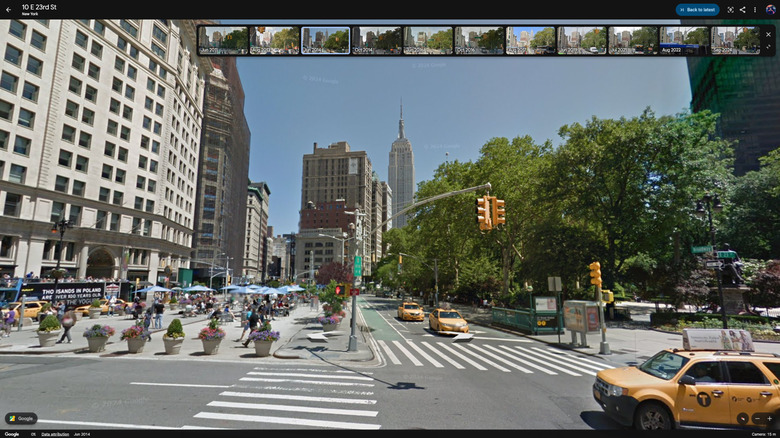
Google kicked things up a notch for Google Earth's 20th anniversary. As of this writing, you can now time travel with Street View. As a refresher, Street View is the feature that allows you to view 3D photos of a location from the perspective of someone standing there. That means you can now get a view of how a specific street looked over time, going back to the earliest Street View photos available.
To activate Historical Imagery in Street View from the browser-based version of Google Chrome, simply drag the icon that looks like a yellow stick figure from the bottom right of the window onto a location on the map. You will enter Street View mode, and you should see a blue button in the top right of the window labeled See More Dates, which will reveal a carousel of dates to choose from. It's also one of the most useful features in Google Maps, where the See More Dates button will appear on the upper right-hand corner under the search bar when in Street View.
There are many locations where this feature is not available, so you may need to try different areas until you find one that works. Clicking the yellow stick figure without dragging it will highlight in blue locations where the feature is available. In our testing, we could not find the option for Street View time travel in the Android version of Google Earth (though it is in Google Maps), nor in the VR version. Here's hoping both are in the works. VR would be especially thrilling for this feature, as seeing these historical images in 3D would make for an incredible immersive experience.