5 Of The Best Apple Watch Apps For Hikers

If you love to experience the outdoors, a great way to explore nature and the world around you is through hiking. You get to breathe the fresh air, exercise, listen to the buzz of wildlife, and just take in nature at your own pace. There are already a bunch of great hiking apps for the iPhone, but sometimes you don't want to carry around the extra bulk. If you're an Apple Watch user, you probably already know you can show your location, but you can improve your entire experience by just using hiking apps designed for your Apple Watch.
Whether you hike to get some exercise or just to see the outdoors, you can get a lot of information from your smartwatch. Things like detailed maps, finding out the distance traveled, the difficulty of trails in your area, and whether trails are kid-friendly are just some things you can have handy on your wrist. Many apps in the App Store will get the hiking information you need, but some are much better than others.
Before you go in, one thing to know is that many hiking apps have free offerings, but some of the best apps will keep certain information behind a subscription. Frankly, if you hike all the time, it might be wise to spend a little money to get the best experience from one of these apps.
AllTrails: Hike, Bike & Run

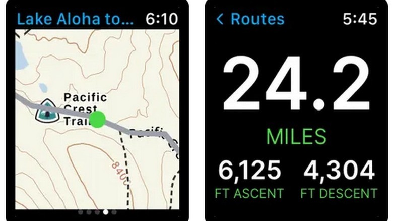
As it says in the name, AllTrails is a great companion for any of your trail-seeking activities. You can plan your routes, find out whether trails are kid- or dog-friendly, get detailed maps of your surroundings, and tons more. You can also track heart rate, distance traveled, and elevation changes, and you can even have it send an alert if you get into trouble on the trail using Life Line. You can download maps in advance in case connectivity might be an issue, and it'll even let you know if you've gone off course with wrong-turn alerts.
As you plan your next hike and have your downloaded maps ready to go, AllTrails also lets you explore other hikers' reviews of trails to get a feel for whether it's the right hike for you. A vibrant community of hikers contributes to the app daily, letting you know trail conditions, possible hazards, great views, and other details important to your planned hike. The app comes with over 400,000 trail maps worldwide, and more are being added every day.
The annual subscription for AllTrails+ is $35.99, but if you want to see if it's right for you, you can do a free seven-day trial. Just don't forget to cancel before time runs out if it's not your cup of tea.
Gaia GPS Hiking, Off-road Maps
Part of hiking, whether it's a day hike or a multi-day journey, is planning your route, checking the weather conditions, and knowing what kind of hike it will be. Gaia GPS is perfect for those things because it focuses on being more of a trail guide than it does the specific stats of your hike. You get detailed trail maps with camping sites nearby for longer adventures and nature routes for exploring everything from back-country trails to national parks. You also can view changing weather conditions and fire maps on the fly, so you know what to expect on the trail.
Included in the free version, Gaia TOPO offers highly detailed trail maps that will help you discover new excursions you can take. Outdoor enthusiasts, in general, will also make use of this app because it offers features and maps for back-country skiing, off-roading, and other outdoor professional applications.
You can use the free version of Gaia GPS if you're just a day hiker and will be within cellular distance, but for longer adventures, you'll need to subscribe for $59.90 annually. A seven-day free trial is also available, so you can try it out before spending money.
Cairn: The Travel Safety App
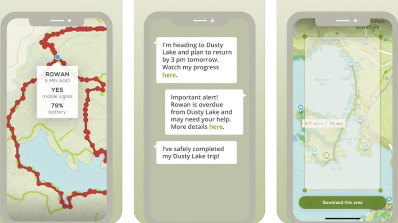
When you go on any hike, it's always important to be on alert, even if it's just in the back of your mind. Hiking can be dangerous; you could fall off the trail, injure yourself, or even get lost. Cairn is a hiking app that offers many of the features of most hiking apps, but safety is at its core. You never know what can happen out there, and having some options for safety never hurts.
With Cairn, you'll be able to view trails near you, but you can also create your own trails if you think you might want to share them or revisit them. You can view maps offline when there's no cellular coverage, and it also has a handy map filter that will show you where other users have found a signal in the area so you can get back online. It offers live tracking so that friends you've entered into the app can keep tabs on your location, and it also has an emergency contact system that will notify contacts with an automated message if you haven't returned from your hike on time.
The free app version doesn't give you much more than basic trail information, putting most safety features behind a paywall. For safety's sake, getting the annual subscription for $26.99 might be wise. There is also a 30-day trial so that you can check it out first.
Komoot - hike, bike, & run
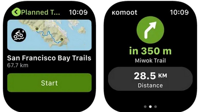
Komoot is a hiking app that has a focus on community and gives a social experience to people all over the world. You can find what people said about the trail in front of you, get recommendations for trails you might have otherwise missed, and learn about trail highlights and viewpoints that others recommend. It has the basics for tracking speed and distance but also offers turn-by-turn voice navigation and offline maps, which are extremely useful when there's spotty cellular coverage. Also, while Komoot focuses on hiking, it's great for mountain bikers and cyclists for its easy to read distance and speed stats on your watch.
What's great about Komoot is that, while it offers a year subscription for $29.99 for maps around the world, it gives you one free region and lets you buy additional regional maps for only $3.99. This is much better because if you're just going to be hiking around your particular region (which is probably most people), you'll only need the free region. If you find yourself hiking in a new area, $3.99 doesn't seem too bad as a one-time payment.
WorkOutDoors
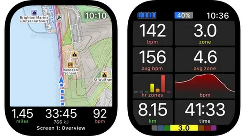
WorkOutDoors is a great Apple Watch app if you like going on hikes. It gives you all the stats you want with speed and distance traveled, heart rate information, maps to make sure you're still on the trail, and much more. What's particularly useful is you can display all of this information in exactly the way you want; all the screens are customizable, so you can set it up the way it makes the most sense to you. With a swipe, you can look at the map, then swipe again to see all of your current health stats, then once again to see your current step count and more. When you're done hiking, you can get a workout analysis in the WorkOutDoors iOS app.
Many hiking apps have somewhat pricey annual subscriptions or multiple in-app purchases, but WorkOutDoors gives you all the bells and whistles for a one-time purchase of $8.99.