LA Fire Forces Police Warning: Don't Trust Map Apps
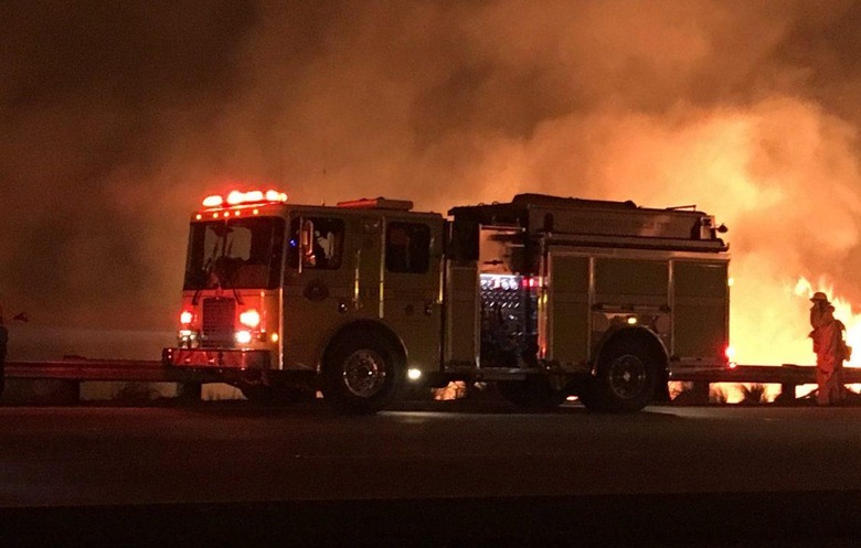
As Los Angeles continues to burn, the LA Police Department has been forced to warn drivers not to trust their navigation apps, which may mistake roads where fires are raging for conveniently open routes. It's proved to be another example of how the Internet of Things may be heavily interconnected, but it isn't quite as smart as it really needs to be in order to be truly reliable.
The problem currently being experienced in LA is an unforeseen side-effect of one of what's ironically the most useful thing about connected navigation apps and services. Google Maps, Apple Maps, and others are able to look at real-time traffic data and offer what are normally smarter routes. Rather than just defaulting to directions for the shortest route, for instance, they can pick a longer path but one which, because of road conditions, would be quicker to travel.
Unfortunately what they're apparently struggling with, The New York Times reports, is figuring out the difference between a little-used road and one that's impassable because of the unexpected LA fires. As a result, they're recommending routes that go through areas affected by the blazes.
Given large chunks of the 405 freeway have been closed at least temporarily, and that the 101 freeway was closed earlier today before being reopened, that's a big problem. Smaller roads are likely to remain closed for longer periods, as firefighters attempt to deal with the fires and as communities are evacuated.
#RyeFire [update] off Rye Canyon Loop, west of Valencia (Los Angeles County) is now 7,000 acres and 10% contained. https://t.co/93hhxUfTfh pic.twitter.com/jTnCMrh7GL
— CAL FIRE (@CAL_FIRE) December 7, 2017
Ironically, it's tomorrow's Internet of Things which could, eventually, fix the problems the current Internet of Things faces. Right now we have plenty of data but little in the way of context. The former is easy to gather, whether it's from sensors tracking smartphone movement, or traffic flow cameras – but the latter often depends on human involvement. Google Maps can tell you where traffic is slower, but it takes something like driver's Waze reports to explain exactly why that's happening if it's not just going to be associated with periodic bottlenecking.
Companies are turning to artificial intelligence (AI) to try to reach those same conclusions without requiring flesh & blood analysis. That requires an exponentially larger amount of sensor data for a start, which relies on developments like cheaper chipsets with lower power requirements and more pervasive interconnectivity. While 5G may be making headlines for its potential to dramatically improve download and upload speeds by 5-10x over today's 4G LTE networks, it'll be just as important for IoT connections that have much lower throughput rates but low-latency and minimal power demands.
That will be combined with on-device processing. It's an important filtering stage, with each sensor capable of making baseline decisions about what's important to report and what can be ignored, rather than the bandwidth and power-heavy alternative of just sending everything to the cloud. In the case of forest fires closing roads, for example, more ubiquitous temperature sensors along the routes could flag up atypical conditions. Always-on microphones could identify emergency service vehicle sirens, or even the sound of the fires themselves.
The data from each sensor in isolation might not be sufficient, but in aggregate – and with AI processing to pull context from that data – it could be enough to make much smarter inferences about conditions. Such sensor deployments needn't be fixed, either: vehicle-to-vehicle (V2V) or vehicle-to-infrastructure (V2I) might turn individual vehicles into roaming data-collectors, identifying unusual traffic conditions alongside helping with self-healing maps and more.
If you're in Los Angeles, and you need navigation help that takes into account the current fire conditions, the California Department of Transportation is recommending QuickMap. That has live updates for road closures and routes affected. It's also suggesting that people potentially in the path of the fires pack their essentials, make sure their car is fully fueled, and to park it facing outward on their driveway for the fastest evacuation.
IMAGE: Cal OES