Apple COVID-19 Mobility Trend Data Released For The Public Good
Today the folks at Apple released a mobility data trends tool to the public for free to aid in citizen care for COVID-19. Our current global pandemic requires that companies like Apple step forward and offer their tech power to assist the world in avoiding sickness and death. Mobility data revealed by Apple today is not attached to any specific user account, and is based instead on user requests for Apple Maps data for directions.
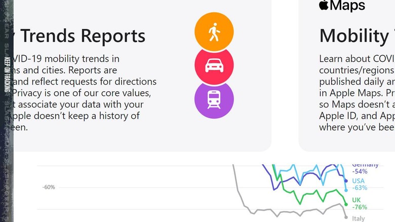
Per Apple's release on the subject this week, Apple's created this new tool for the public using mobility trends for major cities and 63 countries or regions. The data is generation by "counting the number of requests made to Apple Maps for directions." This data is used to show changes in volume of people moving throughout a city. This is slightly different from the contact tracing business – slightly.
Trends show people moving via driving, walking, or taking public transit in the Apple tool, via Apple Maps. Data availability is based on several factors for each city, country, or region. One significant factor in play is the minimum threshold for direction requests made per day. If you live in a region where very, very few people are asking for directions at, for example, 3AM in the middle of the wilderness, you'll get no significant info from Apple's tool.
If you'd like to access this data, take a peek at the site Apple COVID-19 Mobility – as of April 14, 2020. This site may change in the future, but for now, that's the place to go. You can see trends listed with the tool or by downloading a CSV of all the data all at once. If you've got an idea for a project based on the data, let us and/or Apple know!
Apple also recently set in motion an update to Apple Maps with Coronavirus test locations. This update will show "COVID-19 Testing Site" markets where appropriate.