This NASA Satellite Sent The First Radar Images Of Earth's Surface And The Results Are Very Clear
New images of Earth's surface were captured by the NISAR satellite, marking a milestone in a joint space mission between India and the United States. The images depict portions of Maine and North Dakota and were taken with a specialized radar capable of new levels of topographical detail, and which is expected to help predict natural disasters.
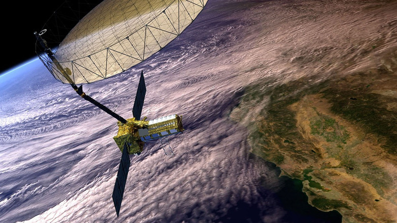
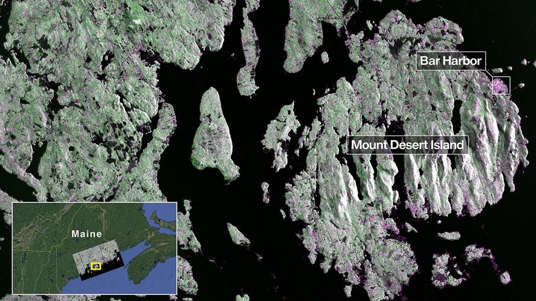
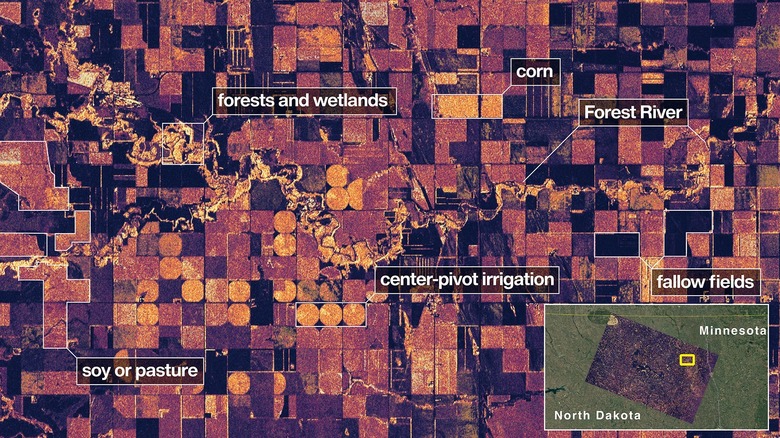
Satellite NISAR, short for the NASA-ISRO Synthetic Aperture Radar, was launched on July 30, and the newly released images were captured on August 21. The images of Maine's coast show an incredible level of detail, with buildings and other hard surfaces clearly differentiated from dense forest and open water. Meanwhile, the images of North Dakota reveal distinctions between forest and wetland, cultivated and fallow fields, and the Forest River versus irrigation systems.
NASA Associate Administrator Amit Kshatriya emphasized the future scientific achievements heralded by the images from NISAR, as well as the deepening collaboration between India and the United States that they represent in an era of increasingly privatized space exploration. In a press release, Kshatriya stated that "By understanding how our home planet works, we can produce models and analysis of how other planets in our solar system and beyond work." But there are more immediate implications for the technology here on Earth, and this may be only the beginning of a new era for development and even disaster prevention.
NISAR will aid climate forecasting and disaster preparation efforts
The images captured by NISAR were taken using the satellite's titular L-band synthetic aperture radar (SAR), which could prove a valuable tool for understanding the pace and scale of climate change, as well as for disaster preparation efforts and forecasting. It works by emitting an energy pulse, which bounces off Earth and is recaptured by the satellite. Compared to traditional photography — even advanced satellite photography — SAR interacts with the physical terrain it captures to give researchers a detailed picture of water bodies, forests, and even soil. An S-band radar is also onboard, which is more suited to vegetation close to the ground. The technology overcomes a variety of obstacles to using radar in space, including the distance from satellite to ground and the speed of its travel.
According to Nicky Fox, the associate administrator of NASA's Science Mission Directorate, NISAR imagery will produce "data and insights that will enable scientists to study Earth's changing land and ice surfaces in unprecedented detail while equipping decision-makers to respond to natural disasters and other challenges." In addition to monitoring agricultural conditions and certain natural ecosystems, NISAR photography will track signs of natural disasters from volcanic eruptions to earthquakes and even landslides. As natural disasters increase with the pace of climate change, NISAR will provide insights for flood mapping, wildfires, oil slicks, glacial motion, and land subsidence, among others. It can track movements down to a centimeter and will continuously monitor the Earth, making two full rotations every 12 days.
NISAR is the result of international scientific collaboration
The images from the NISAR satellite are the culmination of over a decade's worth of scientific collaboration between the United States and India. The satellite takes its name from the respective names of NASA and ISRO (the Indian Space Research Organization), which began their collaboration nearly 11 years ago in September 2014. Both countries are large and climate diverse, with enormous agricultural sectors and potential hazards. The benefit of synthetic aperture radar technology for each nation was clear enough, and as NASA began to explore the technology, ISRO identified complementary mission objectives and signed on.
NISAR was initially meant to launch in 2024, but it was pushed back to 2025 when NASA discovered that the satellite's antenna was at risk of exposure to high temperatures. In order to resolve the issue, a special coating was added. Even after that work was completed, the launch had to wait until after February 2025 to avoid putting NISAR into an orbit that would also expose it to fluctuating temperatures.
NISAR finally launched from the Satish Dhawan Space Centre at Sriharikota in Andhra Pradesh, India, at 6 p.m. on July 30. With the satellite now in orbit and its first images taken as proof of the mission's success, it is expected to continue taking images and measurements that can be used to advance scientific research. It is currently on a baseline mission of three years, though it's likely the joint project will continue in some fashion if it continues to bear out. NASA, for its part, has big plans, with its next major venture being a lunar mission over 50 years since the last one.