Tracking Bill Nye's Solar Sailer LightSail
LightSail has deployed, and with it, a Mission Control Center with the ability to predict where the solar sailer will be moving above the Earth as it makes its important journey. The good news is that this solar sailer will be passing over the United States. The bad news is – it's probably already passed over you for the first time if you're reading this article in the late afternoon. This won't be the only opportunity you get to be close to a solar sailer, on the other hand, as development will continue well into the future with The Planetary Society.
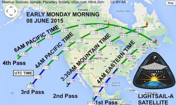
The image you see above shows predicted travel times of the sailer as of 10 hours ago, courtesy of Jason Davis of the Planetary Society who was given the mashup map by Bonnie Crystal of HFLink. People around the world are tracking and watching the solar sailer as it drags across the sky. Below you'll see Cees Bassa tracking the LightSail, finding it's a bit earlier on its track compared to estimates.
High drag from deployed sail lowers orbit and causes @exploreplanets #LightSail to be early vs blue pre-deploy orbit. pic.twitter.com/PvZqIH07RH
— Cees (@cgbassa) June 8, 2015
Below you'll see the first version of the sailer back in September of 2014 – for scale. This image comes courtesy of The Planetary Society, captured on its deployment table at Cal Poly San Luis Obispo after a "day-in-the-life test". Image captured by Justin Foley.

According to Davis, if you're tracking the sailer and want to catch a glimpse, you should "look for flyovers that occur around dawn and dusk."
"The best time to see any spacecraft, including LightSail," said Davis, " is when you are standing in Earth's shadow but the spacecraft is still illuminated by sunlight."
"If you're going outside to look, consider starting a few minutes earlier than our listed times."
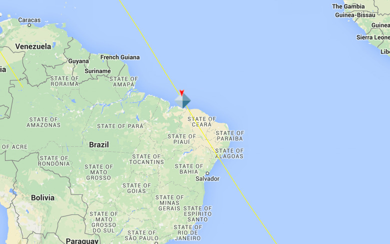
At the time this article was being written, LightSail-A was cruising down toward the East side of South America at a speed of 4.62 miles a second.
That's 277.2 miles per hour.
LOCAL TIME: 09:54:23
UTC: 14:54:23
LATITUDE: 12.59
LONGITUDE: -51.30
ALTITUDE [km]: 449.15
ALTITUDE [mi]: 279.09
SPEED [km/s]: 7.44
SPEED [mi/s]: 4.62
AZIMUTH: 112.7 ESE
ELEVATION: -22.9
RIGHT ASCENSION: 07h 19m 12s
DECLINATION: -32° 47' 58”
You can track the solar sailer through N2YO's live map – capture a screenshot and share with us! If you happen to capture a photo of the sailer above you, share the photo with us and the world, as well!