The Physical Brexit Study: How Close To Pangea?
A study has been conducted which shows when England began to break away from Europe physically, creating the Dover Strait. Using bathymetric maps to study the bottom of the sea, scientists have discovered a lot more than what's previously been known about the area and the sequence of events that created today's topography. Britain, it turns out, was connected to the mainland (last time it was connected, that is) via a chalk ridge that kept a giant proglacial lake in check – until disaster struck.
A large amount of spillage from the lake created by a chalk dam created the beginnings of what have turned into the Dover Strait. From Calais in France to Dover in England, a chalk ridge kept a massive lake at bay until it spilled over. This glacial lake's spillage was likely inevitable – unless, of course, there was something to keep that glacier nearby as cold as is required to keep solid forever.
Another set of lakes overflowed after the chalk ridge event. These lakes created the Lobourg Channel. By the end of this overflow event, the entirety of what is now the United Kingdom was effectively separated from the rest of Europe.

Above you'll see several stages between the Permian period with Pangea and the broken-apart set of land masses we have on Earth today. This set of events took place over a very, very long period of time. These images come from Earthguide Online Classroom.
The breaking apart of Pangea took place starting hundreds of millions of years ago. As of 65-million years ago, what would eventually become North and South America had nearly broken away entirely from the African and Asian continents. It was much, much more recent that England's land mass started to break away from the rest of Europe.

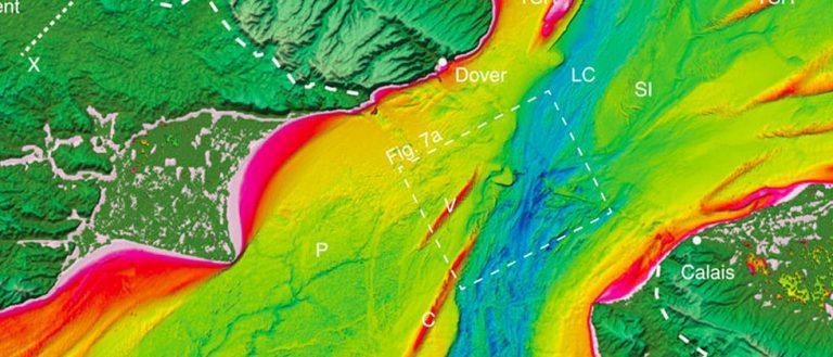
ABOVE: "(a) Coloured and shaded relief multibeam bathymetry map of the Lobourg Channel. SI, streamlined island; TSR, tidal sand ridge. Water depth is indicated by colour bar. Location of image is shown in Fig. 1. (b) Three-dimensional perspective view of cataract at head of Channel 2 looking N. Sc, prominent scours in bedrock. Vertical exaggeration is ∼2. Water depth is indicated by colour bar. Dashed line indicates line of seismic profile in Fig. 8. (c) Map view of floor of Lobourg Channel showing prominent longitudinal lineations (ridges and grooves) (L). Orientation of lineations is indicated by double-headed arrow. SD, sand dunes. Location of image is indicated on a. Water depth is same as in colour bar in a."
The timing of the beginning of this breaking away of England from the rest of Europe was said in this study to have stared at around MIS 12. That's Marine Isotope Stage 12, otherwise known as the Anglian stage – that's between 478,000 and 424,000 years ago. The break continued for quite some time. The study suggests that the second event likely occurred around 160,000 years ago.
Researchers suggest that the break will have likely been mainly complete by MIS 5e – that's the Eemian or Ipswichian stage. As such, around 123,000 years ago the UK was likely completely separate from the rest of Europe. The study suggests that "by MIS 5e, marine mollusc assemblages from coastal deposits indicate full connection of the Channel with the North Sea during the interglacial highstand."
In other words, it took around 355-thousand years for England to break away from the rest of Europe. It's assumed that the Brexit in 2017 will be complete in a considerably smaller amount of time. The results of this newer Brexit may or may not be more of an environmental mega-event on England this time around – we shall see!
For more information on this subject, see the paper "Two-stage opening of the Dover Strait and the origin of island Britain." This paper can be found under code doi:10.1038/ncomms15101 in Nature Communications. This paper was authored by Sanjeev Gupta, Jenny S. Collier, David Garcia-Moreno, Francesca Oggioni, Alain Trentesaux, Kris Vanneste, Marc De Batist, Thierry Camelbeeck, Graeme Potter, Brigitte Van Vliet-Lanoë, and John C. R. Arthur.