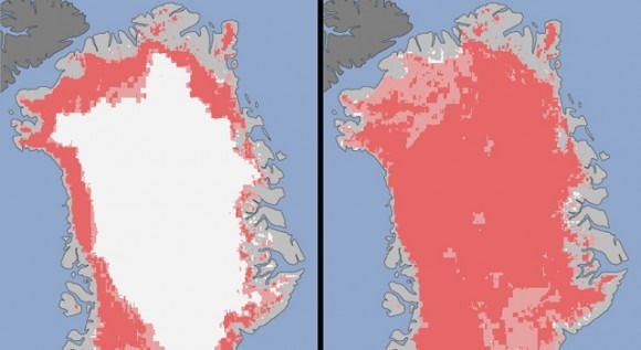
Satellite Shots Show Intense Greeland Ice Sheet Melt
On July 8, around 40% of the massive ice sheet that covers the country of Greenland was at a point of thawing at or near the surface. But by July 12, that amount had risen to 97%. Just check out the image here. Anything in light pink is classified as "probably melt" while areas in dark pink are simply classified as "melt."
The images come from NASA, showing that the melted area is the greatest it has ever been in the 30-year history of satellite observations. This doesn't lead to any specific conclusions about global warming or climate change, or to the cause of why this massive ice sheet is melting, but the images don't lie and this is clearly an issue. This kind of ice melt has historically only occurred once every 150 years on average.
"The Greenland ice sheet is a vast area with a varied history of change. This event, combined with other natural but uncommon phenomena, such as the large calving event last week on Petermann Glacier, are part of a complex story. Satellite observations are helping us understand how events like these may relate to one another as well as to the broader climate system," said NASA cryosphere program manager Tom Wagner.
[via NASA]
