NASA RainCube Mini Weather Satellites May Improve Forecast Accuracy
In July, NASA astronauts on the International Space Station deployed a small satellite called RainCube that monitors storms and sends information about them to researchers. The tiny CubeSat sent back its first storm images in August, relaying data it had captured of a storm over Mexico. Following that, RainCube then captured images of Hurricane Florence's first rainfall.
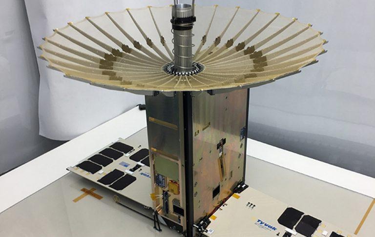
RainCube stands for Radar in a CubeSat, the name pointing toward the satellite's primary purpose: using radar signals for real-time weather monitoring. The goal behind the initial mission is simple — testing whether such satellites could be used one day to improve forecasts. RainCube on its own won't be able to fulfill that mission, but many working together might get the job done.
Existing ground-based forecasting tools have helped to greatly improve the quality of weather forecasts over the years, but they can still get things wrong. CubeSats contributing to forecast data from low Earth orbit may change that.
NASA calls this CubeSat a "mini-rain radar" and explains that many of these devices could be "flying together like geese" to track storms. The cost to launch each individual RainCube is low, relatively speaking, making it feasible to launch many for higher quality storm monitoring. Whether a fleet of CubeSats will ever be used for this purpose is yet to be seen.
Talking about the research is NASA JPL Center of Climate Sciences director Graeme Stephens, who said:
What RainCube offers on the one hand is a demonstration of measurements that we currently have in space today. But what it really demonstrates is the potential for an entirely new and different way of observing Earth with many small radars. That will open up a whole new vista in viewing the hydrological cycle of Earth.