NASA Mars Orbiter Finds Thick Layers Of Exposed Water Ice On Martian Slopes
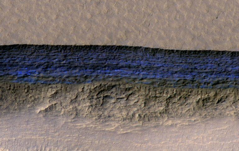
NASA has released an enhanced image taken by the Mars Reconnaissance Orbiter's (MRO) HiRISE camera; in it, we see layers of underground ice that are exposed on the Mars landscape. The space agency says the MRO found a total of eight locations where these thick ice layers are exposed, all of them on eroding slope faces. Researchers explain that regions like this may mean frozen water will be more easily accessible to humans and robots than previously anticipated.
NASA has published two enhanced images of one of these locations, the first (above) showing a close-up enhanced view of the ice layers; the second (below) showing the same angle at a further distance so that its place in the landscape is more easily discerned. The images have been enhanced so that the ice is bright blue and therefore easy to spot.

Researchers say the ice most likely started out as snow that was deposited far back in Mars' history. They exist as pure water ice today, with rock and dust cemented in layers throughout it. It's an exciting discovery, giving researchers cross-sections of exposed Martian surface and, therefore, Mars history. They "give us a 3D view with more detail than ever before," according to Colin Dundas, the study's lead author.
The underground ice's existence was known to NASA thanks to its previous work with its Mars Odyssey orbiter, MRO's ground-penetrating radar, plus the ESA's Mars Express orbiter. However, these exposed regions offer a direct look at this underground ice in a big way. Questions remain about how the exposed regions formed, though.
In addition to providing researchers with a direct view of these surface layers, the regions also hold promise for much easier access to water. Study co-author Shane Byrne said, "Astronauts could essentially just go there with a bucket and a shovel and get all the water they need." The regions will also make it much easier to get samples for learning about Mars' climate history.
SOURCE: NASA