Google Maps Traffic Footprint Expands
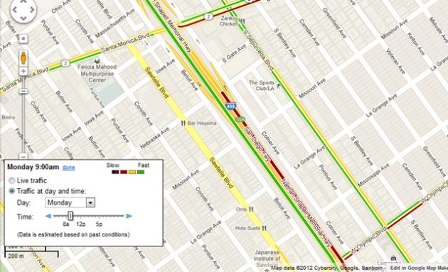
Google has updated its Maps platform recently with more advanced traffic information, particularly on highways and major roadways. Now, the search giant is expanding that initiative so that if you notice there's a streak of sluggish cars on your planned route, you'll know exactly what side streets are the best alternative. The company wants to help make the world a less frustrating place, one gridlock at a time.
In a post on an official blog, Maps engineer Szabolcs Payrits wrote, "Have you ever been stuck in traffic during the heavy morning commute, or found yourself late for dinner plans because you left work right in the middle of the Friday night traffic? Knowing the usual highway conditions during certain times of the day, like rush hour, can help you avoid traffic. And if you plan to avoid these highways, it's also helpful to know the typical traffic patterns on the surrounding arterial roads." Very true.
After all, have you ever taken that closest exit on the highway to avoid the traffic jam, only to find yourself in a worse mess as soon as you pull onto the exit ramp? Google Maps will now let you do that. The new update includes what Google calls "important arterials" or alternatives to the highway in numerous major cities around the US and the world. Google, as it has previously, will use data from Android-toting motorists who share their information while on the road in order to calculate the traffic projections.
[via VentureBeat]