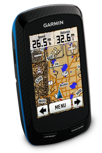
Garmin Edge 800 cycling PND packs custom maps with no calibration
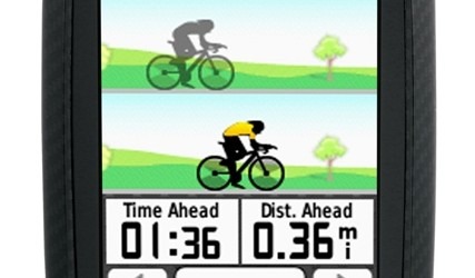
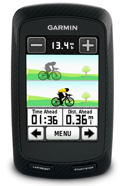
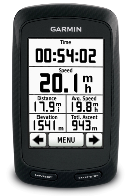
Garmin has outed its latest PND, and the Edge 800 is targeted at cyclists either prone to getting lost or wanting to track their performance. A compact unit with a 2.6-inch color touchscreen, the Edge 800 comes with a simple twist-on handlebar mount and can track not only position but speed, distance, time, elevation, calories burned, climb and descent. Pair it with an ANT+ compliant monitor, meanwhile, and you can also record heartrate and speed/cadence (sensor depending).
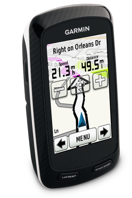
Using Garmin's Custom Maps software, owners can manage their own topographical data or load on preconfigured packages, such as City Navigator maps, stored on a microSD card. The Edge 800 also supports satellite imagery, and requires no calibration if moved between bikes: the company says you can simply twist it off the mount and snap it onto a different cycle.
Battery life is up to 15hrs of standalone use, and you can share trails and other information via Garmin's Connect web forum. No word on pricing or availability at this stage.
Press Release:
Touchscreen Edge® 800 from Garmin® Blends Best of All WorldsStreamlined Data, Route Planning and Color Mapping
OLATHE, Kan./August 26, 2010/Business Wire — Garmin International Inc., a unit of Garmin Ltd. (NASDAQ: GRMN), the global leader in satellite navigation, today announced the feature-packed touchscreen Edge 800 for cyclists who want accuracy and simplicity when tracking their statistics and location for racing and recreation. Edge 800 seamlessly combines the most popular aspects of the industry-leading Edge 500 and Edge 705 while adding an intuitive touchscreen interface. New mapping options such as Garmin's BaseCamp route planning and BirdsEye™ Satellite Imagery make it perfect for training, touring and riding on the trail. Edge 800 will debut at Interbike (Booth 2631) and Eurobike (Booth A5-201), where it won the coveted Eurobike Award for electronic components.
"Whether you're on the road, in the mountains or around the city, Garmin's touchscreen Edge 800 puts the most important information of your ride at your fingertips," said Dan Bartel, Garmin's vice president of worldwide sales. "Thanks to its simple mounting system, improved mapping and route-planning capabilities, and the GPS-based features that make wires and calibration obsolete, we can easily say that one Edge fits all."
Building on its popular predecessors, Edge 800 is smaller and sleeker than the Edge 705, yet features a larger 2.6" display with a simple touchscreen interface. And while Edge 800 gets its streamlined design from the ultralight Edge 500, the color display and versatile mapping options make exploration more enjoyable and efficient than ever. The latest version of Garmin's free BaseCamp software (www.garmin.com/basecamp) gives users an easy tool to survey the terrain and plan routes. BaseCamp lets users plan and preview routes – along with viewing elevation changes – and then send those routes to Edge 800, Edge 705 and Edge 605 as courses to follow.
In its third year as title sponsor of the Pro Tour cyclists of Team Garmin-Transitions, Garmin has worked closely with the sport's top athletes in developing Edge products that can be appreciated by cyclists around the world using a cycling computer to get their fastest time – or for the first time.
"At Garmin-Transitions, we're going to be on the cutting edge of technology, in everything we do," said Team Garmin sprinting sensation Tyler Farrar. "Edge 800 can track all of our performance data, and it also keeps things interesting on training rides because we can use it anywhere in the world to plan and follow new routes – on and off road – and always find our way back to the start."
Cyclists can view Team Garmin's featured rides – or download, analyze and share rides of their own – at Garmin Connect™ (http://garminconnect.com), the free-to-join online community of more than 30 million activities from around the world. Garmin Connect displays metrics such as time, distance, speed, elevation and heart rate through charts and a variety of map representations, including street, satellite, topographic, and elevation maps. Garmin Connect users can search for activities in their area and try them by uploading the data to Edge 800, which will guide the way.
"I can come back and do even more on the computer when I download it," said Team Garmin's Christian Vande Velde of combining Garmin Connect with the Edge products he used in consecutive top-8 finishes at the Tour de France. "It takes all the guessing out of everything in my training."
Using information directly from GPS satellites, Edge 800 accurately tracks speed, distance, time, GPS position, elevation, calories burned, climb and descent. For even more real-time data on display, Edge 800 syncs wirelessly through ANT+™ technology with compatible third-party power meters as well as Garmin heart rate monitors and speed/cadence sensors. For extra-precise climb and descent data, Edge 800 incorporates a barometric altimeter to pinpoint changes in elevation.
Because Edge 800 requires no calibration, it can be switched quickly between bikes thanks to a low-profile, quarter-turn mount that fits easily on the stem or handlebars with tight-gripping rubber rings. Boasting a high-sensitivity GPS receiver with HotFix that quickly acquires and maintains satellite reception, Edge 800 displays temperature readings, changes time zones automatically, lasts up to 15 hours on one charge and alerts riders if they're moving but the timer has not been started.
As powerful as it is for performance cyclists and speed specialists, various mapping options make Edge 800 an ideal device for singletrack exploration, everyday errands and casual commuting.
On the trails, using a separate TOPO U.S. 24K DVD or microSD card brings you the highest level of topographic detail available, with maps comparable to 1:24,000 scale USGS maps, featuring terrain contours, topo elevations, summits, routable roads and trails, parks, coastlines, rivers, lakes and geographical points. In town, optional City Navigator mapping provides detailed street maps, millions of preloaded points of interest and onscreen turn-by-turn directions to your destination.
Subscribers to BirdsEye Satellite Imagery can quickly transfer high-resolution satellite images to Edge 800 and seamlessly integrate those images into the onscreen maps to get a true representation of the surroundings. And Garmin's Custom Maps can bring the details, labels and landmarks of your existing paper or electronic map to Edge 800 in just a few simple steps.
Edge 800 is the latest breakthrough from Garmin, which has spent more than 20 years developing technologies and innovations to enhance users' lives, making Garmin a household name in the automotive, aviation, marine, wireless, outdoor and fitness industries. For more about pricing and availability, as well as information about Garmin's other products, go to www.garmin.com and www.garmin.blogs.com. For more about Team Garmin, visit www.garmin.com/teamgarmin.