Sky Survey Map Shows Tens Of Thousands Of Supermassive Black Holes
An international team of astronomers has published a new map of the sky and within that map is more than 25,000 supermassive black holes. The map is the most detailed celestial map in the field of low radio frequencies. It was built by astronomers using 52 stations with LOFAR antennas across nine European countries.
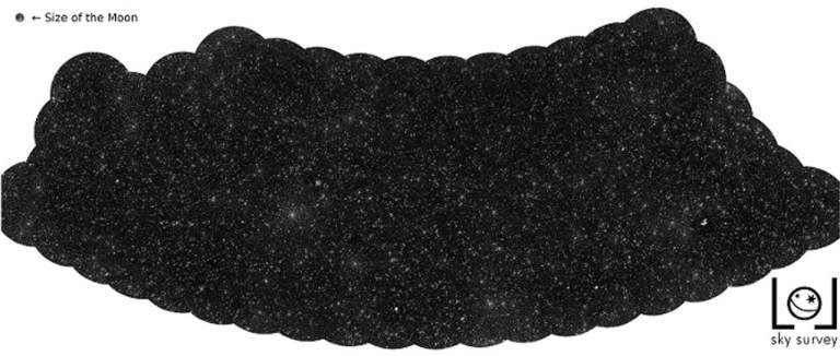
One glance at the image above, which is a small snapshot of the sky survey map, and all the little dots look like stars. Scientists note that the dots are all supermassive black holes, with each black hole located in a different, distant galaxy. Radio emissions picked by the antennas scattered across Europe are emitted by matter ejected as it neared the black hole. Researchers on the study say the map results from many years of hard work using "incredibly difficult data."
The team had to invent methods to convert radio signals into images of the sky. Compiling the map of the sky required scientists to combine 256 hours of observations of the northern sky. Supercomputers running new algorithms to correct for the ionosphere's effects had to perform their work every four seconds. Despite the vast number of supermassive black holes in this image, the map covers only four percent of the northern half of the sky.
Astronomers on the research team say they will continue mapping the sky until the entire northern sky is complete. Researchers say the map also gives insights into large-scale structures of the universe along with other information.
The researchers did not indicate how long it might take to complete the entire sky map. One of the biggest challenges in making the map was that observations at longer radio wavelengths are difficult because of the Earth's ionosphere. The team describes the ionosphere as a cloudy lens constantly moving across the radio telescope.