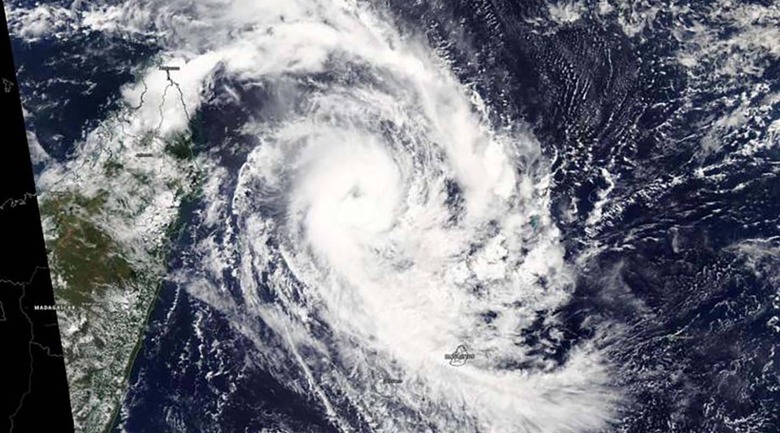
NASA's Aqua Satellite Snaps New Image Of Tropical Cyclone Herold
Tropical Cyclone Herold, the big storm impacting northeastern Madagascar, is the subject of a new satellite image from NASA. The space agency's Aqua satellite captured an image of the storm's eye on Monday, the same day the image was published and only days after the cyclone began to form. The satellite image shows the eye of the storm, as well as higher clouds and 'powerful bands.'
The Tropical Storm Herold, which was formerly known as Tropical Cyclone 22S, formed on March 13 and has spent the past couple of days inching closer to Madagascar. The weather event started out as a tropical cyclone and later transformed into a full tropic storm, eventually reaching its current hurricane-force level.
Earlier today, NASA says that its Aqua satellite moved over the Southern Indian Ocean and used its 'Moderate Resolution Imaging Spectroradiometer' instrument (MODIS) to spy on the storm. The space agency notes that the cyclone was located around 295 nautical miles northwest of St. Denis on La Reunion Island.
At this point in time, the Joint Typhoon Warning Center expects that Herold will start turning to the southeast today, eventually reaching a speed of 104MPH and then fizzling down to a subtropical level. The storm is incredibly powerful and is dumping large amounts of rain on Madagascar.
As of late Monday local time, AccuWeather reports that the storm was the equivalent of a Category 2 hurricane. Over the weekend, Herold dumped more than 8 inches of water in some parts of the northeastern island. The storm isn't expected to reach subtropical levels until the second half of this week.
