NASA OSIRIS-Rex To Use Natural Feature Tracking For Bennu Landing
NASA has its spacecraft OSIRIS-REx set to land on the surface of the asteroid Bennu and return samples to Earth for study. Originally NASA intended to have the spacecraft use LIDAR to navigate to the surface of the asteroid. That plan has now changed after discovering that the landing site on the asteroid was much smaller than anticipated.
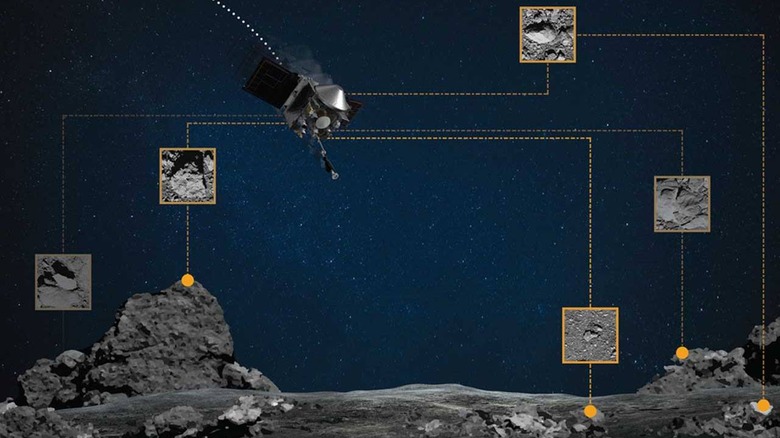
That smaller landing site requires a navigation method that is much more precise. OSIRIS-REx will now use a navigation method called Natural Feature Tracking (NFT) to finding its landing area, which the team is calling the "Bullseye TAG." The system requires the creation of a high-resolution catalog on the spacecraft.
To create that catalog, the spacecraft made reconnaissance passes over the primary and backup sample collection sites. The spacecraft flew as low as 0.4 miles over the surface of Bennu to collect images of the landing sites. Using that catalog of images, the team identified boulders and craters that might pose a risk to the spacecraft.
NFT will autonomously guide the spacecraft to the surface of the asteroid by comparing the onboard image catalog with the real-time navigation images taken during descent. As the spacecraft descends to the surface of the asteroid, NFT updates the predicted point of contact depending on the position in relation to landmarks. Controllers created "hazard maps" for both landing sites to document all the features that could potentially harm the spacecraft.
If the spacecraft predicts during the descent that it will land in an unsafe zone, it will abort the landing and back away from the surface. NFT will be used in April to navigate during the first sample collection rehearsal. The first sample collection is set for late August with a departure from Bennu set for 2021 with samples back on Earth by 2023.