Google Street View Visits Skyfall-Inspired Hashima Island
The Google Street View Trekker backpack is at it again, and this time it visited the abandoned Hashima Island, or more well-known as "Dead Island" or "Dead City" from the most recent James Bond film Skyfall. In the movie, the island serves as the cyberterrorists headquarters, but it's actually a real place and now we get to experience it for ourselves.
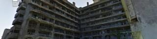
The island is located some 18 miles off the coast of Nagasaki in Japan, and it once was bustling with coal-mining activity when the Mitsubishi Corporation purchased the island in 1890. The island had numerous housing projects that crammed in residents comprising of coal workers and their families. Although Skyfall wasn't actually filmed their, the inspiration for Dead Island came from Hashima.
It took two hours for a single Google employee to take photos and map the island using the Trekker backpack that we've seen in the past. The island isn't that big — only 480 meters long and 150 meters wide, but it was large enough to house approximately 5,000 people. The island was deserted in 1974, and it's been laying in ruins ever since.
Previously, we've seen the Google Street View Trekker backpack visit the Grand Canyon and the Burj Khalifa, as well as the Galapagos Islands, where anyone with an internet connection can explore these places without leaving the comfort of their home. Of course, it would be a lot better to see them in real life, but this is definitely the next best thing.
Most recently, Google started to allow third-parties to borrow the Trekker backpacks in order to map out areas for themselves and add them to Google Maps. The Trekker is relatively small piece of hardware, and it consists of a backpack that you throw over your shoulders with a ball that raises up over your head. This ball consists of 15 lenses that snap a full 360-degree panorama every 2.5 seconds, all controlled by an Android device.
SOURCE: Google Japan Blog