Apple preps transit directions for iOS 9 and uses robots to map interiors
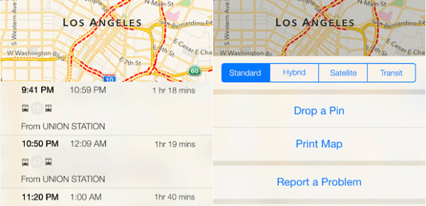
Apple has some new ideas in the works for improving its Maps in iOS 9. First, Apple quietly acquired GPS company Coherent Navigation and it's precision–within centimeters–GPS technology. Furthermore, Apple is continuing its deal to use TomTom's mapping information, and now Apple will be adding transit directions to the mix. Whether you're looking for bus, subway, or train directions, Apple will be able to direct you through your commute.
Users will now be able to plan trips on public transport from directly with the app. After Apple abandoned Google Maps in favor of its own proprietary service, Apple Maps users would have had to open a separate app if they needed transit directions. The updated maps will give users transit arrival and departure and will direct them through changes for multi-leg trips.
The new addition of transit information comes with larger transit icons on Apple Maps, allowing users to identify stations faster when glancing at the full map.
Apple is also reportedly working on mapping building interiors, starting with its own Cupertino offices. Instead of the wearable, backpack Trekker cameras enlisted by Google for the great outdoors, Apple is using robots to carry out its indoor mapping. The robots are apparently like little Roombas equipped with iBeacon sensors. It's unlikely Apple's indoor maps will be available anytime soon, but we're likely to hear more about the transit features at Apple's upcoming WWDC next month.
Source: 9to5 Mac