USGS releases first ever global topographical map of Mercury
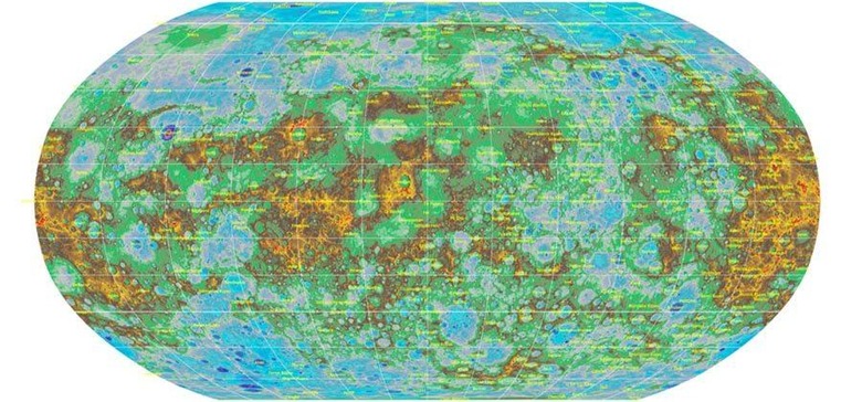
The U.S. Geological Survey (USGS) has released the first-ever global topographical map of Mercury, something that was made in conjunction with Arizona State University, Carnegie Institute of Washington, Johns Hopkins University, NASA, and the Applied Physics Laboratory. The topographical map, as one would expect, includes details on things like tectonic landforms, craters, and volcanoes, and is high-res enough for those future road trips across the galaxy.
The data was acquired using the Mercury Surface, Space Environment, Geochemistry, and Ranging (MESSENGER) spacecraft belonging to NASA — the very first spacecraft to make an orbit around Mercury, and one that provided scientists with a bundle of information on the planet.
That data was used by a team of researchers to assemble the topographical map you see above. The data was gathered during a massive 4,104 orbits around Mercury over the span of a few years. More than 100,000 images from the spacecraft were used to find features (that is, landforms), with the use of "sophisticated new software applications" playing a role in the map's creation.
In a statement, USGS Astrogeology Science Center Director Lazlo Kestay said:
The creation of this map is a prime example of the utility and beauty that can come out of overcoming complex cartographic problems. This highly aesthetic product literally provides a whole new dimension to the study of Mercury images, opening many new paths to understanding the surface, interior, and past of the closest planet to the sun.
View the map here.
SOURCE: USGS