NASA's new Saharan dust blanket images reveal its massive size
NASA has published images that reveal the blanket of dust from the Saharan dust storm as it moves across the ocean toward the Americas. This isn't a new phenomenon — the dust has gravitated this way before many times. However, NASA notes that this particular dust storm's resulting blanket has been 'quite expansive.' Using the NASA-NOAA Suomi NPP satellite, the space agency is able to give the public a detailed look at this event.
NASA uses a variety of satellites to keep an eye on our planet, tracking everything from global groundwater resources to natural phenomena and transient issues like wildfires, dust storms, and similar events. This year's Saharan dust storm is no exception, with NASA using its satellites to track the spread of the dust cloud across the ocean.

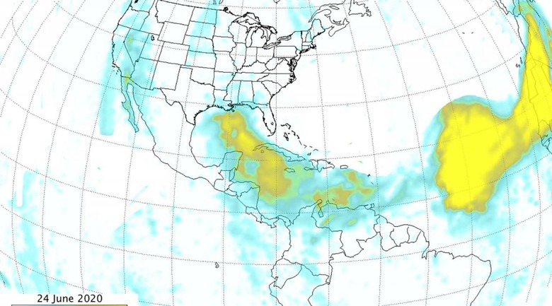
According to the space agency, the dust blanket proceeded to cover the Yucatan Peninsula in Mexico on June 23 and 24; it was also entering southern Texas by that time. As of June 24, the dust plume's thickest parts had expanded from covering 1,500 miles on June 18 to a massive 5,000 miles.
Though dust particles like the kind being spread could potentially have a negative effect on human respiration, the event isn't entirely bad. NASA notes that the particles spread from the dust storm can also help build up beaches and fertilize the land. As well, the widespread effects of the Saharan dust storm may ultimately help reduce the intensity of and even suppress tropical cyclones.
NASA Goddard Space Flight Center atmospheric scientist Colin Seftor, the researcher who created the imagery, explained:
While Saharan dust transport across the ocean to the Americas is not uncommon, the size and strength of this particular event is quite unusual. Also, if you look off the coast of Africa you can see yet another large cloud coming off the continent, continuing to feed the long chain of dust traveling across the Atlantic.