NASA Releases iPad App For Exploring Earth
NASA has been all about exploring space, but now with their space shuttle program winding down and the imminent decommissioning of the International Space Station, it's time to focus on exploring Earth. Well, at least that's what the freshly launched NASA Visualization Explorer app will help you do on your iPad. The app packs in real-satellite data along with a plethora of informational stories, movies, and still images.
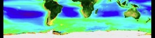
The app explores various topics such as climate change, Earth's dynamic systems, as well as the plant life both on land and in oceans. Data captured by NASA satellites are visualized into variety of maps, charts, and diagrams. Also included are six editorial features about Earth science, which will be augmented with two editorials each week with topics possibly covering the sun and solar system as well.
NASA hopes to make the Earth science data that they've collected over the years of research more accessible by everyone, with the visualizations helping to make it also more easily understandable. They've already offered a NASA App HD that features thousands of images from their image bank along with an iPhone app with similar features. This new NASA Visualization Explorer app can be downloaded from the Apple App Store.
[via CNET]