MIT self-driving car tech navigates with only GPS and sensors
One thing common among self-driving cars right now is that for safe navigation they require 3D maps that are labeled by hand. A breakthrough at MIT will change that if the tech comes to market. MIT's system can navigate, even on country roads, using only GPS and sensor data. MIT's Daniela Rus says that the need for these dense 3D maps has limited where modern autonomous cars can operate.
With current autonomous cars, much of the population will be unable to use self-driving features. Roads that are unpaved, unlit, or not reliably marked are not navigable by current autonomous rides. MIT's Computer Science and Artificial Intelligence Laboratory (CSAIL) have developed a framework called MapLite that allows self-driving cars to operate on raids that they've never driven and that lack 3D maps.
MapLite uses simple GPS data of the sort used by Google Maps and a bunch of sensors that observe road conditions. Those elements work together to allow the test vehicle to autonomously drive on multiple unpaved roads in Devens, Massachusetts. The vehicle was able to reliably detect the road more than 100-feet in advance.
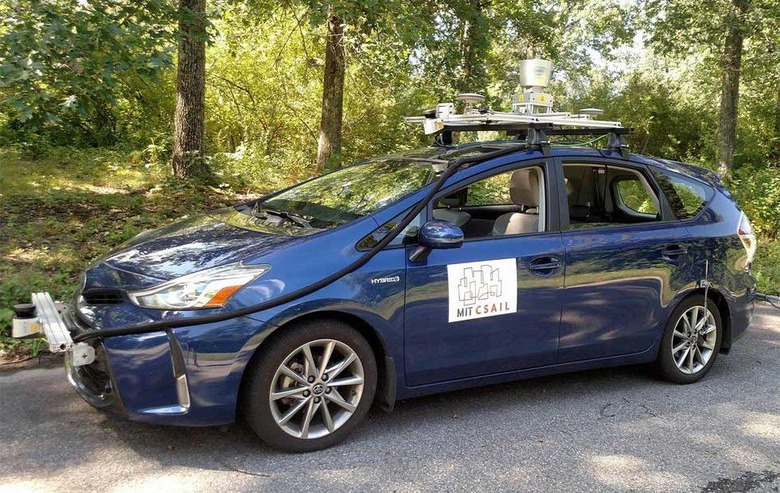
The vehicle used by the team was a Toyota Prius that was fitted with a range of LIDAR and IMU sensors. MIT researchers plan to present a paper covering their system at the International Conference on Robotics and Automation in May.
MapLite uses sensors for all aspects of navigation and only relies on GPS data to obtain a rough estimate of the location of the car. The system sets a final destination and what the team calls a "local navigational goal that must be in view of the car sensors. The perception sensor then creates a path to get to that point using the LIDAR to find road edges.
SOURCE: MIT