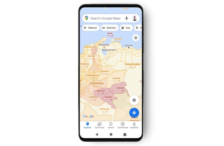
Google Maps gets new layer with data on recent COVID-19 cases around the world
Google has announced a new layer of data that is rolling out in Google Maps, giving users information about COVID-19 case numbers for cities, states, and countries around the world. With this information, Google Maps users can readily see whether the area they're in or planning to visit currently a hot zone, ultimately helping users make more informed choices about their activities. The feature will be limited to mobile users.
The newly announced feature is simple to use, according to Google, which says that under the layers button in the top right corner of the app, users will now see a new option called 'COVID-19 info.' With this, and using data pulled from a variety of reputable sources, Google Maps users will be presented with the average number of new COVID-19 cases per 100,000 people in the region from the past seven days.

Google says that it is rolling out this new layer feature in all of the 220 territories and regions in which the platform is available. This information will be provided at the city, county, province, state, and country level, the company explains, stating that it is getting the case information from sources like the New York Times and Johns Hopkins University.
The data offered by these sources is itself sourced from major health agencies and organizations, including the World Health Organization and hospitals. This new layer is in addition to the coronavirus pandemic information Google provides in its Search platform, which includes local, state, and national data on COVID-19.
Google Maps users will find the new COVID-19 overlay on Android and iOS starting this week, though it will take some time to roll out to all users. This information joins other relevant details offered on Maps, as well, such as the live busyness meter that shows how crowded a shop may be at the moment, as well as a graph showing the most popular times that people visit the destination; these make it easier to avoid crowds.
