Google Maps create 2011 Japan earthquake and tsunami archive
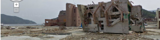
For those of you wishing to get up close and personal with the destruction and collapse of massive parts of Northeastern Japan as crushed up by the earthquakes and tsunami from March 2011, you can certainly do so thanks to Google Maps new initiative to archive images of the area in the weeks after the disasters unfurled. In addition to being able to see these areas inside Google Maps (until they're updated as repairs are made and new images are collected), you can see before and after shots at a special site Memories for the Future, fully optimized for a browser-centric experience. What do you think, citizens of earth, is this a suitable memorial for the terror that occurred earlier this year?
You can explore the area with Street View on Google Maps, one of the greatest ways to explore any area you've never been to before as you can look forward, backward, left and right, and double-tap to zoom in on any given area. Of course there are strange bits that change as you go down the road as not all images are photographed at the same moment, but without a doubt this is the best way to get in close to an area you might never have otherwise experienced had Google Maps never existed. The entirety of the 44,000 square kilometers of affected areas have been captured by Google Maps cars, as well as they could.
Now we've got to wonder how much of history we've missed because Google Maps hasn't had Street View for enough years to capture such similar events as the bombing of London, massacres across China in the years before World War II, and of course the Dark Ages. Can you imagine Google Maps cars capturing piles of plague-ridden corpses? The humanity of it all! Head to Google Maps right now and jump in on Northeastern Japan to see the knocked over buildings for yourself — head to that Memories for the Future site for the best look at how truly devastating the effects have been.
[via Google+]