Google coronavirus mobility tracker rates where social distancing is working
Google is using anonymized location data to highlight how well people are following stay-at-home orders and coronavirus social-distancing guidelines, releasing new reports that rate Community Mobility. The system taps the same tracking tools Google has used to show things like popular store hours, based on things like smartphone location.
In happier, less pandemic-focused times, that data was relied upon to add the "busy period" graphic to business listings in Google Maps. By looking at aggregated, anonymized location data for multiple users, Google could calculate when stores and other locations were typically busier than others.
The hope for the Community Mobility Reports, of course, is that the trend goes the other way, and shows a drop in activity. According to Karen DeSalvo, MD, M.P.H. and Chief Health Officer at Google Health, the company has been approached by public health officials hoping for more insight into COVID-19 reactions. As such, Google is applying the same tools to mapping the impact of work from home and shelter in place policies, which are increasingly being implemented around the world.
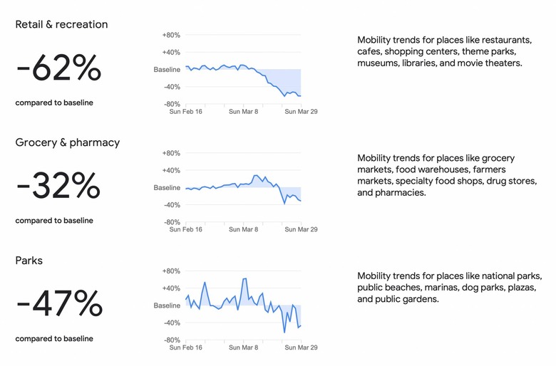
"The reports use aggregated, anonymized data to chart movement trends over time by geography, across different high-level categories of places such as retail and recreation, groceries and pharmacies, parks, transit stations, workplaces, and residential," DeSalvo explains. "We'll show trends over several weeks, with the most recent information representing 48-to-72 hours prior."

Initially, Google plans to release reports covering 131 countries and regions. Some of those will have regional level data, too, depending on what's available. More locations will be added in the coming weeks.
While there's been an uptick in social scolding – and worse – for those not following the recommendations around distancing, Google argues that its reports are intended to help official COVID-19 management, not shame areas.
"In addition to other resources public health officials might have, we hope these reports will help support decisions about how to manage the COVID-19 pandemic," DeSalvo explains. "For example, this information could help officials understand changes in essential trips that can shape recommendations on business hours or inform delivery service offerings. Similarly, persistent visits to transportation hubs might indicate the need to add additional buses or trains in order to allow people who need to travel room to spread out for social distancing."
As with the original Google Maps features, the coronavirus mobility tracker will use a few techniques to avoid overstepping on privacy. No personally identifiable information – such as specific location, movement, or contacts for a single person – will be released. Google also uses differential privacy to add artificial noise to the dataset, so that it can't be retroactively used to identify any one individual.
It relies on Location History being turned on, too, which Google sets to off by default. If you've had that enabled, and would prefer not to, you can switch it off in the Google Account settings either on your smartphone or through the browser, as well as delete what information Google has stored.
While this isn't the first time we've seen location data used to draw COVID-19 mobility conclusions, what sets it apart is the likely scale of the information Google has to work with. The popularity of its products – and the number of people who have probably enabled Location History – could well make this one of the more accurate insights into how the ongoing pandemic has changed our behavior.