Garmin Oregon rugged GPS range made official
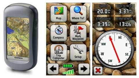
Garmin's new Oregon handheld GPS range, the existence of which was tipped earlier this week when product descriptions hit the online stores, has been officially confirmed by the company. Five models are available, ranging from the the basic Oregon 200 and shaded relief-mapped Oregon 300, to three 400-series devices each tailored to different outdoor activities. Each model has a 3-inch color touchscreen and water & shock resistant casing.

The 200 has a simple basemap onto which custom mapping or charts can be loaded via microSD. At the other end of the range, the 400t is aimed a hikers, with preloaded U.S. topographic maps in 3D elevation perspective; the 400i offers shoreline details, depth contours and boat ramps for U.S. inland lakes and navigable rivers intended for anglers. Finally, the 400c has salt water chart coverage for the coastal U.S. and Bahamas.
Garmin's HotFix functionality uses cached satellite data to speed up location re-fix, and there's also a proprietary wireless connection (except on the 200) that can be used to share data between Oregon units as well as connect heart-rate monitors and speed/cadence sensors. Five usage profiles – automotive, marine, recreation, fitness and geocaching - make sure the most suitable options in each activity are most prominent.
Each GPS weighs 6.8oz and Garmin promise 16hrs from two AA batteries. The range starts from $480 for the Oregon 200, rising to $640 for the 400-series models, and will be on sale in Q3 2008.