Australian scientists undiscover small Pacific island
With the modern age of satellite mapping and Google Maps, you might expect that the map of Earth's landmass, including islands, around the globe is correctly and accurately mapped. However, it appears that errors in mapping do occur as evidenced by a group of geologists from the University of Sydney who undiscovered a small Pacific island. The small island is in the Coral Sea and is called Sandy Island.
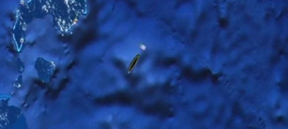
For over a decade Sandy Island has appeared as a dark shape in the Coral Sea off the coast of Australia. A group of scientists on geographic expedition decided to visit the island while on an expedition to study plate tectonics. The scientist discovered that the island lay in their path and decided to investigate.
However, what they discovered was unexpected – the island doesn't exist. The scientists say that while the island appeared on Google Earth maps, there were no images of it. Sandy Island also appeared on the known to be reliable world coastline database, but there were no signs of the island on their sea charts.
The scientists say they went to the bridge of the ship to check the navigation charts used by the captain and the island was nowhere to be found. The scientists decided to sail their ship through where the island was supposed to be. The ship captain was understandably nervous about running aground, but the scientists say the ocean floor never got shallower than 1300 m below the wave base.
Danny Dorling, president of the British Society of Cartographers said, "You can't create a perfect map. You never will," he said. "Our current world map is a collection of highly accurate satellite maps and some of the oldest data collected from Admiralty charts."
He said the mistake would've been substantial had it been in a heavily trafficked sea lane, but "The Coral Sea is in the middle of nowhere."
[via Guardian]