Seaview Is Google Street View For The Oceans
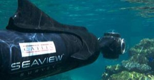
I would imagine we're all familiar with Google Street View. A new service has been announced that uses a small underwater scooter operated by a diver with a camera on the nose that slips through the ocean and photographs 360° images that is an underwater Street View type offering. The service is called the Catlin Seaview Survey, and it is joint venture between the University of Queensland, Google, and insurance firm Catlin Group.
The service will initially offer a spectacular photographic tour of the Great Barrier Reef in Australia. Later, another reef in Bermuda will also be photographed using the service. So far, the service only has a few sample images that are viewable at Seaview.org. The project will go into full swing this September and begin surveying at 20 different points around the 2300 km long Great Barrier Reef. The expedition will also create data that will be used to determine any damage to the reef's over time caused by ships or other issues.
As the footage is captured at each of the sites, it will be moved to the Seaview website. The diver controlling the camera-laden scooter will cruise along at depths between 30 and 100 m. Apparently other submersibles will be used as well. It's interesting that some of the camera gear used in the survey was developed specifically for this task. One of the cameras used has for SLR cameras inside fitted with extreme fisheye lenses shooting simultaneously to get the 360° images. Aideo is also being captured in each location and will be placed on a dedicated channel on YouTube.
"For the first time in history, we have the technology available to broadcast the findings of an expedition through Google. Millions of people will be able to experience the life, the science and the magic that exists under the surface of our oceans," says the survey's chief scientist, Ove Hoegh-Guldberg of the University of Queensland in Brisbane.
[via NewScientist]