Roll Your Own 3D GPS Navigation System
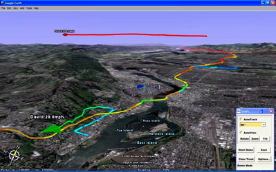
Satellite navigation used to be cool, but since every Tom, Dick and Harriet picked up a cheap unit for their car it's now passé. One way to pump a bit more "sexy" into it is to improve the quality of the graphics, and building a 3D landscape to drive through is a damned good way of doing that. Rather than going to the trouble of doing all that terrain-mapping himself, Alexander Rose took advantage of Google Earth and a Bluetooth GPS to put together his own DIY solution.

Using an intermediary software bridge called Goops (handily donation-ware) you can track your progress, colour code it depending on things like speed or direction, and even track multiple networked units on the one display. Perfect for formation freeway driving!
Kevin Kelly [via lifehacker]