Only from space could we spot thousands of underwater mountains
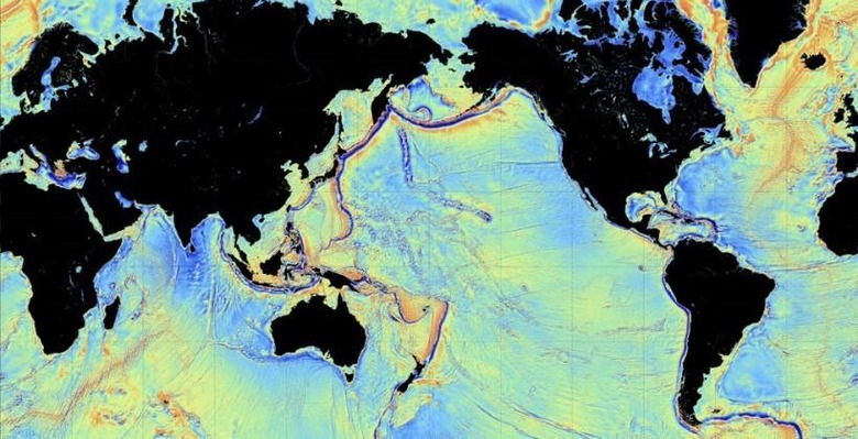
Not for nothing is it said that we know more about the surface of the moon and nearby planets than we do about the ocean floor, and things have got a whole lot more interesting down there with the discovery of thousands of new deep sea mountains. The freshly-discovered ranges – which could add more than 25,000 known peaks on top of the roughly 5,000 we'd already identified – come as researchers increase the resolution of marine modeling using not submarines and robots but satellites instead.
While it might seem counter-intuitive to look down from space rather than actually go underwater, in fact the technology has some distinct advantages. Radar altimeters carried by satellites CryoSat-2 and Jason-1 can track the pull of gravity on the surface of the ocean: deep trenches cause it to lower, while higher peaks drive it up in response.
It's not a new approach, but what a research team led by David Sandwell at the University of California, San Diego discovered was a way to tease out more resolution, spotting peaks 1.5km (0.9 miles) tall rather than the 2km of existing underwater topographical maps.
In contrast, echo-sounding from ships can produce high-resolution results, but with no small amount of effort. In fact, the BBC says, only around 10-percent of the oceans have been surveyed using the technology.
While it may only be a 0.5km difference, Sandwell's team has opened up an exponential increase in underwater mountain discovery. Peaks covered in deep layers of sediment have also been spotted, hitherto invisible to instruments.
In all, the team believes it's a roughly two-fold increase in resolution using the new satellite data. Results so far have included an "extinct" spreading ridge in the Gulf of Mexico, believed to have been active 180 million years ago, in addition to a ridge in the South Atlantic Ocean said to have separated when Africa and South America parted ways all of 85m years ago.
VIA BBC
SOURCE Science