Live USA Map Of Unmanned Drones Released By EEF

The term "unmanned aerial drone" might strike a bit of fear into your heart when you see the live tracking map of the USA that's been made available this week by the Electronic Frontier Foundation, but not to worry – not all of them are flying overhead right this minute. Instead this is a map that's the result of the EEF's Freedom of Information Act lawsuit that covers the FAA (Federal Aviation Administration)'s full knowledge of unmanned flights across the United States and what you're looking at is a tracking of project licenses rather than actually flying objects. That said, this map is exciting in its coverage for our greater understanding of unmanned drone flight projects as initiated by state and local law agencies, universities, and US Military operations.
The newest information here comes from – for the first time, mind you – the Air Force, Marine Corps, and DARPA (Defense Advanced Research Projects Agency). These three Military branches have for the first time had their records shown to the public in all cases save for one. That one case is if these flights are only taking place inside their own "restricted airspace" – over their own military bases. Click the map below to see the live map via the EEF and Google Maps.
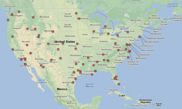
Across this map you're going to be able to see drones of many types, with the Air Force testing cute little hand-launched Raven, Puma, and Wasp drones from Aerovironment on the short end. On the larger end you'll find the scary types of drones, those being the Predator and Reaper drones you may have heard of flying missions overseas in live warzones.
Some of the lighter uses of drones you'll be finding across the USA are straight from places like the University of Michigan where a "Flying Fish" drone can be found. This drone is made to float over open water for human tracking and is able to reposition itself through flight when it's moved too far away from its original and intended spot. The U of Michigan also has a drone made to study "persistent solar-powered flight" and goes by the name YellowTale.
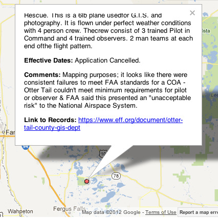
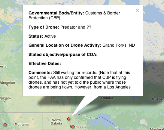
Have a peek up north in Minnesota and you'll find two basic extremes, one of them being a flight that's been cancelled due to "unacceptable risk" to the National Airspace System. The other you'll find right near the border with North Dakota and is set for Customs & Border Protection – that one lists a Predator drone and an unknown drone, with the FAA not being especially clear on where the drones are being flown.
Keep your eye on the map and let us know if you find anything interesting as more information is added in the future!
[via The Verge]