Google Maps Street View ads panoramic imagery from Grand Canyon
Back in October, we reported that the Google Maps Street View team took to the Grand Canyon to capture imagery from the beautiful landmark with their new Trekker camera backpacks. Today, Google has released the Street View imagery in all of its panoramic glory. Over 9,500 images of Grand Canyon were taken by the Google Maps team.
The images cover over 75 miles of trail all around the Grand Canyon, including this scenic route, and now you can hike the trails yourself without even getting up from your desk. Of course, the experience won't be as fulfilling as actually being there, but at least you can see for yourself through images what you're missing out on.
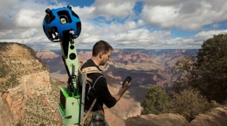
Google used specially-designed "Trekker" backpacks that are Android-powered essentially include 15 camera lenses that capture 360 degrees of landscape at once. The backpacks weigh about 40 pounds, so if you can imagine walking around with that thing under the hot sun of the American southwest, then you probably have a good idea of what it was like for the Google employees.
Google didn't say what they'll do next with the Trekker backpacks, but I'm sure we'll be seeing more stunning landmark Street View imagery in the future, including other trails and areas around the world where the Trekker could only do the job. On a related note, the company added more info and imagery to some of the "world wonders", so if you get bored with the Grand Canyon, hop on over there to explore even more.