Google Maps Opens North Korea
Google Maps has begun to fill in the blanks on North Korea, using crowd-sourced geography data to add roads and city data about the secretive country. The new information has been gathered though Google Map Maker, the search giant's tool to allow road names, points-of-interest, new routes, and cartographical errors to be manually added and amended by users themselves. The North Korean data has been several years in the making, Google says.
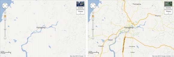
As the comparison photos of Pyongyang above show, the new data being added is considerable. Where previously there was little beyond the river system, now there are highways, district information, and green spaces all marked on the crowd-sourced map.
Nonetheless, there's still plenty of work to be done, something Google is the first to concede. "We know this map is not perfect" Jayanth Mysore, senior product manager for Google Map Maker says of the updated information. "One of the exciting things about maps is that the world is a constantly changing place."
Mysore argues that keeping the North Korean maps updated is about more than just Google's hunger for data, or catering to public fascination with the country. Many citizens in South Korea have "ancestral connections or still have family living there," for instance.
Future approved changes to the North Korean mapping in Google Map Maker will also be rolled out to Google Maps. Google's efforts in the country have been in the headlines earlier this month, too, after chairman Eric Schmidt travelled there to discuss the importance of internet openness.