Google Adds Transit Layer To Google Maps
Google has gone and added a new feature to its already expensive Google Maps service. This feature allows users to quickly find public transit routes in over 50 cities across the US with the transit layer. In order to turn the transit layer on just click the more button located towards the top left of the pat interface and check Transit.
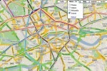
Google's Transit site has been offering automatic trip-planning for a while now, but the new feature makes it really easy to determine your route or if there is even an option for you with just a glance at the map. The map displays just an overlay of the routes with color-coding to distinguish between the available modes of transportation.
The thing that sets these maps apart from the ones provided by major metro lines are that these are geographically correct and provide more than just the transit lines. Google certainly does not give up on a service, they continually add new useful features and great support for all of the content they provide.