Garmin eTrex Legend H & Vista H navigators, plus new BaseCamp app
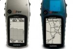
Garmin have announced two new portable navigation devices intended for hikers and climbers. The eTrex Vista H and eTrex Legend H both feature a fast satellite receiver, capable of establishing a positioning lock even when under tree cover or in canyons, together with a fast USB interface for transferring waypoints and topological maps. They also each have 24MB of internal storage.
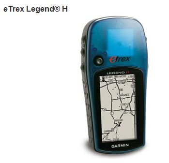
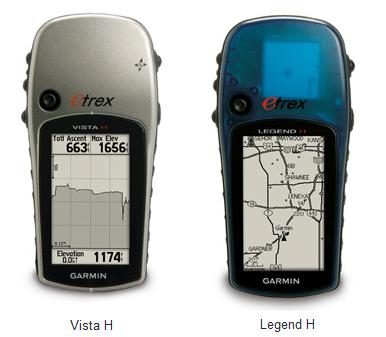
Both units ship with basemaps of North and South America, which include major lakes, rivers, cities, interstates, national and state highways, railroads and coastlines; each has a high-contrast 2.4-inch grayscale screen. The eTrex Vista H adds an electronic compass and barometric altimeter.
Garmin have also announced a new software tool, BaseCamp, which can be used to plan journeys as well as review them. The package supports geotagging of photos – as well as instant mapping from photo metadata – plus Google Earth rendering and geomapping.com compatibility.
"BaseCamp lets users view both 24K and 100K topo maps in 2D or 3D renderings. Users no longer are confined with a "north up" map – it can be rotated to any orientation. Another convenient window depicts the elevation profile currently displayed. And with Track Draw, users can trace a fluid track and get an immediate elevation profile to determine the difficulty of their hike"
The Garmin eTrex Legend H has an MRSP of $149.99; the eTrex Vista H has an MSRP of $199.99. Garmin BaseCamp, meanwhile, will begin shipping with all new TOPO U.S. 24K DVD and TOPO U.S. 100K DVD products in Q1 2009; it will also be available, at the end of the quarter, as a free download for existing TOPO U.S. 2008 owners.

Press Release:
Garmin® Updates Popular eTrex® ModelsOLATHE, Kan./January 14, 2009/Business Wire — Garmin International Inc., a unit of Garmin Ltd. (NASDAQ: GRMN), the global leader in satellite navigation, announced today the eTrex Legend H and the eTrex Vista H – low-cost handheld navigators that include several new features considered vital for today's outdoor adventures.
First and foremost, the units include a high-sensitivity GPS receiver, which makes satellite acquisition faster and helps ensure a solid lock, even in dense tree canopies or vertical canyons that hikers, hunters, and geocachers often experience. The eTrex Legend H and eTrex Vista H also feature a fast USB interface and 24 megabytes of internal memory for loading detailed topo maps from a computer. The eTrex Vista H includes an electronic compass and barometric altimeter as well.
"The eTrex Legend and Vista models have long been considered standard equipment for anyone who wants to make the most of their outdoor excursions," said Dan Bartel, vice president of worldwide sales. "Now, entry-level customers can get some of the latest features for the same price as the previous versions, making the units attractive for those wanting a rugged and reliable GPS for under two hundred dollars."
Both units contain a basemap of North and South America, containing major lakes, rivers, cities, interstates, national and state highways, railroads and coastlines, which can be viewed on the units' high-contrast 2.4-inch (diagonal) grayscale screen.
The eTrex Legend H has a manufacturer's retail price of $149.99, and the eTrex Vista H has an MSRP of $199.99. For more information, visit www.garmin.com.
Press Release:
Introducing BaseCamp™: Garmin's® New Tool For Planning and Reviewing All of Your Outdoor AdventuresOLATHE, Kan./January 14, 2009/Business Wire — Garmin International Inc., a unit of Garmin Ltd. (NASDAQ: GRMN), the global leader in satellite navigation, announced today the introduction of Garmin BaseCamp – a utility that allows users to plan and manage trips, routes, tracks, and waypoints and transfer them between the computer and applicable Garmin outdoor handheld device.
"BaseCamp brings a whole new set of features to hikers, hunters, geocachers, and anyone else who wants to maximize their experience with their Garmin GPS," said Dan Bartel, Garmin's vice president of worldwide sales. "This new utility lets users view, organize, and transfer their data more quickly and efficiently – allowing them to make the most of their time exploring the great outdoors."
BaseCamp lets users view both 24K and 100K topo maps in 2D or 3D renderings. Users no longer are confined with a "north up" map – it can be rotated to any orientation. Another convenient window depicts the elevation profile currently displayed. And with Track Draw, users can trace a fluid track and get an immediate elevation profile to determine the difficulty of their hike.
Because a picture is worth a thousand words, BaseCamp supports geotagging of user-generated photos, to know exactly what the scenery is like at any given location – simply click on a map icon to view an enlarged version of a photo. Users can even view their data in Google Earth. The growing legions of Geocachers will also find utility in BaseCamp – the utility fully supports all of the information presented on geocaching.com.
Whether you're planning an adventure or returning home from one, BaseCamp allows the complete transfer of maps, waypoints, routes, and geotagged photos back and forth between the utility and the applicable Garmin outdoor handheld device. Users can compile their information into easily-identifiable folders as well, for later retrieval. As a backup, BaseCamp can print out configurable, full-page, color maps for viewing at any time.
BaseCamp is compatible on both PC and Mac computers. Beginning in the first quarter of 2009, the utility will ship with all new TOPO U.S. 24K DVD and TOPO U.S. 100K DVD products. For those who currently own TOPO U.S. 2008, BaseCamp will be available for a free download at www.garmin.com at the end of the first quarter 2009. For unit compatibility and more information, visit www.garmin.com